


St Maurice la Tuilerie

Auger91
User
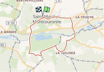

Length
7.2 km

Max alt
112 m

Uphill gradient
121 m
Km-Effort
8.8 km

Min alt
58 m

Downhill gradient
120 m
Boucle
Yes
Creation date :
2025-03-22 16:42:15.874
Updated on :
2025-03-22 16:43:18.293
1h59
Difficulty : Medium

FREE GPS app for hiking
 SityTrail
IGN / Geographical institutes
SityTrail Plus
The world is yours!
About
Trail Walking of 7.2 km to be discovered at Ile-de-France, Essonne, Saint-Maurice-Montcouronne. This trail is proposed by Auger91.
Positioning
Country:
France
Region :
Ile-de-France
Department/Province :
Essonne
Municipality :
Saint-Maurice-Montcouronne
Location:
Unknown
Start:(Dec)
Start:(UTM)
435217 ; 5381367 (31U) N.
Comments