


Parcours chemin Orne

Antoine Declais
User
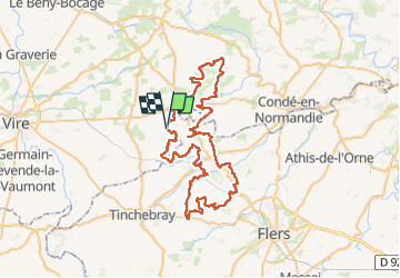

Length
67 km

Max alt
299 m

Uphill gradient
1023 m
Km-Effort
80 km

Min alt
104 m

Downhill gradient
1021 m
Boucle
Yes
Creation date :
2025-03-23 12:08:50.305
Updated on :
2025-03-23 12:09:44.023
2h00
Difficulty : Very easy

FREE GPS app for hiking
 SityTrail
IGN / Geographical institutes
SityTrail Plus
The world is yours!
About
Trail Moto cross of 67 km to be discovered at Normandy, Orne, Moncy. This trail is proposed by Antoine Declais.
Positioning
Country:
France
Region :
Normandy
Department/Province :
Orne
Municipality :
Moncy
Location:
Unknown
Start:(Dec)
Start:(UTM)
668708 ; 5411521 (30U) N.
Comments