


St menges

staunn
User
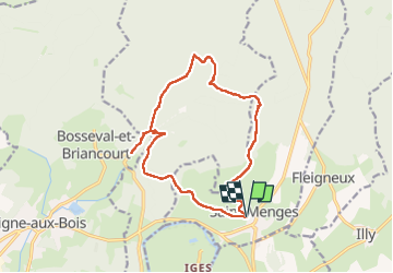

Length
14.4 km

Max alt
358 m

Uphill gradient
334 m
Km-Effort
18.8 km

Min alt
181 m

Downhill gradient
335 m
Boucle
Yes
Creation date :
2025-03-23 08:47:58.501
Updated on :
2025-03-23 12:28:02.632
3h39
Difficulty : Difficult

FREE GPS app for hiking
 SityTrail
IGN / Geographical institutes
SityTrail Plus
The world is yours!
About
Trail Walking of 14.4 km to be discovered at Grand Est, Ardennes, Saint-Menges. This trail is proposed by staunn.
Description
marche
Positioning
Country:
France
Region :
Grand Est
Department/Province :
Ardennes
Municipality :
Saint-Menges
Location:
Unknown
Start:(Dec)
Start:(UTM)
638586 ; 5511470 (31U) N.
Comments