


Tête du Rissace

orsel
User GUIDE
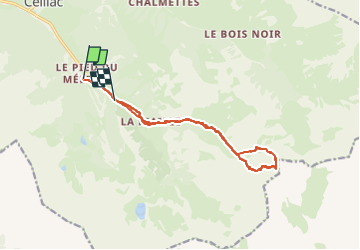

Length
13.5 km

Max alt
2941 m

Uphill gradient
1249 m
Km-Effort
30 km

Min alt
1690 m

Downhill gradient
1117 m
Boucle
No
Creation date :
2025-03-23 07:30:01.257
Updated on :
2025-03-23 16:53:02.323
5h39
Difficulty : Medium

FREE GPS app for hiking
 SityTrail
IGN / Geographical institutes
SityTrail Plus
The world is yours!
About
Trail Touring skiing of 13.5 km to be discovered at Provence-Alpes-Côte d'Azur, Hautes-Alpes, Ceillac. This trail is proposed by orsel.
Positioning
Country:
France
Region :
Provence-Alpes-Côte d'Azur
Department/Province :
Hautes-Alpes
Municipality :
Ceillac
Location:
Unknown
Start:(Dec)
Start:(UTM)
324917 ; 4946385 (32T) N.
Comments