


Baillarguet

JEANJOSY
User
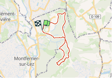

Length
7.5 km

Max alt
127 m

Uphill gradient
137 m
Km-Effort
9.3 km

Min alt
62 m

Downhill gradient
137 m
Boucle
Yes
Creation date :
2025-03-24 12:52:43.122
Updated on :
2025-03-24 16:03:31.218
1h47
Difficulty : Easy

FREE GPS app for hiking
 SityTrail
IGN / Geographical institutes
SityTrail Plus
The world is yours!
About
Trail Walking of 7.5 km to be discovered at Occitania, Hérault, Montferrier-sur-Lez. This trail is proposed by JEANJOSY.
Positioning
Country:
France
Region :
Occitania
Department/Province :
Hérault
Municipality :
Montferrier-sur-Lez
Location:
Unknown
Start:(Dec)
Start:(UTM)
570129 ; 4836579 (31T) N.
Comments