


JE THEIZE Oingt Joncin 27Km 40Kf

azipat
User
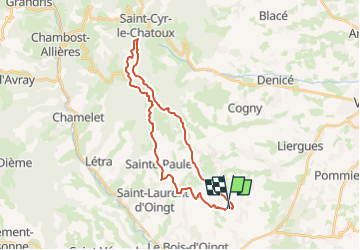

Length
27 km

Max alt
866 m

Uphill gradient
968 m
Km-Effort
40 km

Min alt
354 m

Downhill gradient
968 m
Boucle
Yes
Creation date :
2025-03-24 16:18:27.288
Updated on :
2025-03-24 16:27:55.378
5h39
Difficulty : Medium

FREE GPS app for hiking
 SityTrail
IGN / Geographical institutes
SityTrail Plus
The world is yours!
About
Trail Equestrian of 27 km to be discovered at Auvergne-Rhône-Alpes, Rhône, Theizé. This trail is proposed by azipat.
Description
30 mars 2025
Positioning
Country:
France
Region :
Auvergne-Rhône-Alpes
Department/Province :
Rhône
Municipality :
Theizé
Location:
Unknown
Start:(Dec)
Start:(UTM)
625029 ; 5088619 (31T) N.
Comments