


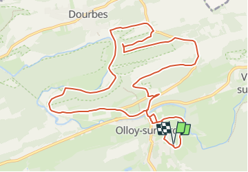
Olloy-Rolinvaux-Dourbes

asblicare
User


0m
Difficulty : Very easy

FREE GPS app for hiking
 SityTrail
IGN / Geographical institutes
SityTrail Plus
The world is yours!
About
Trail Equestrian of 12.5 km to be discovered at Wallonia, Namur, Viroinval. This trail is proposed by asblicare.
Description
Au départ du manége Rolinvaux à Olloy, vous quittez Olloy en vous dirigeant vers la carrière de Frimoye d'où un chemin forestier vous emmène vers Dourbes. Vous remonter vers Haute Roche avant de revenir vers Olloy par La Goulette.
Positioning
Comments