


Vercors Sornin maison communale

c.gourme
User
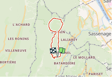

Length
10.3 km

Max alt
1571 m

Uphill gradient
675 m
Km-Effort
19.3 km

Min alt
911 m

Downhill gradient
674 m
Boucle
Yes
Creation date :
2025-03-25 08:51:29.0
Updated on :
2025-03-25 14:27:12.944
5h34
Difficulty : Difficult

FREE GPS app for hiking
 SityTrail
IGN / Geographical institutes
SityTrail Plus
The world is yours!
About
Trail Walking of 10.3 km to be discovered at Auvergne-Rhône-Alpes, Isère, Engins. This trail is proposed by c.gourme.
Positioning
Country:
France
Region :
Auvergne-Rhône-Alpes
Department/Province :
Isère
Municipality :
Engins
Location:
Unknown
Start:(Dec)
Start:(UTM)
705536 ; 5007139 (31T) N.
Comments