


Lengarnayre Coudon

pb07
User
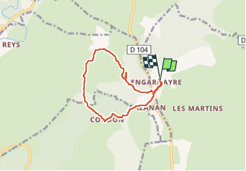

Length
6.2 km

Max alt
246 m

Uphill gradient
93 m
Km-Effort
7.4 km

Min alt
187 m

Downhill gradient
93 m
Boucle
Yes
Creation date :
2025-03-25 13:34:00.725
Updated on :
2025-03-25 16:13:26.897
1h55
Difficulty : Medium

FREE GPS app for hiking
 SityTrail
IGN / Geographical institutes
SityTrail Plus
The world is yours!
About
Trail Walking of 6.2 km to be discovered at Auvergne-Rhône-Alpes, Ardèche, Chandolas. This trail is proposed by pb07.
Positioning
Country:
France
Region :
Auvergne-Rhône-Alpes
Department/Province :
Ardèche
Municipality :
Chandolas
Location:
Unknown
Start:(Dec)
Start:(UTM)
598047 ; 4919889 (31T) N.
Comments