


08 - Locronan - moyenne

guy77340
User
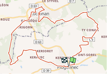

Length
14.7 km

Max alt
283 m

Uphill gradient
345 m
Km-Effort
19.3 km

Min alt
60 m

Downhill gradient
344 m
Boucle
Yes
Creation date :
2025-03-25 19:20:29.238
Updated on :
2025-03-28 15:17:48.781
4h22
Difficulty : Very difficult

FREE GPS app for hiking
 SityTrail
IGN / Geographical institutes
SityTrail Plus
The world is yours!
About
Trail Walking of 14.7 km to be discovered at Brittany, Finistère, Plogonnec. This trail is proposed by guy77340.
Positioning
Country:
France
Region :
Brittany
Department/Province :
Finistère
Municipality :
Plogonnec
Location:
Unknown
Start:(Dec)
Start:(UTM)
411291 ; 5325642 (30U) N.
Comments