Trail Walking Saint-Agnan-en-Vercors - Vercors - La Coche Grand Veymont Queyrie - Photo

Vercors - La Coche Grand Veymont Queyrie

 Alfredy
Alfredy

User

© OpenStreetMap contributors
Length
Length
24 km
Max alt
Max alt
1931 m
Uphill gradient
Uphill gradient
685 m
Km-Effort
Km-Effort  
33 km
Min alt
Min alt
1359 m
Downhill gradient
Downhill gradient
685 m
Boucle
Boucle
Yes
Creation date :
2014-12-10 00:00:00.0
Updated on :
2014-12-10 00:00:00.0

(1 Reviews)

Walking
Walking
7h22
Difficulty : Unknown

Scan this QR Code to open this trail in the SityTrail application

FREE GPS app for hiking

Logo SityTrail SityTrail

IGN / Geographical institutes

Download SityTrail from the App Store Download SityTrail from Google Play

Logo SityTrail SityTrail World

The world is yours!

Download SityTrail from the App Store Download SityTrail from Google Play Download SityTrail on Huawei AppGallery

About

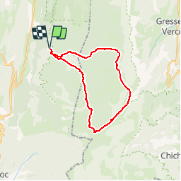
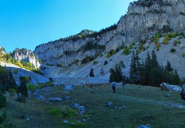
Trail Walking of 24 km to be discovered at Auvergne-Rhône-Alpes, Drôme, Saint-Agnan-en-Vercors. This trail is proposed by Alfredy.

Description

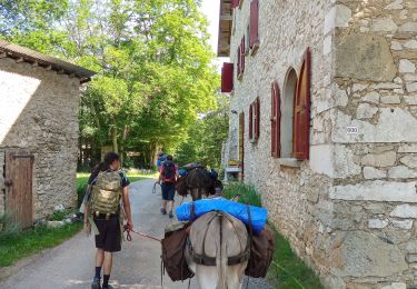
Le départ se fait depuis un parking situé juste avant la maison forestière de la Coche (située sur les hauts plateaux du Vercors entre Rousset et St-Agnant-en-Vercors. 1200m après la sortie de Rousset sur la D518 en direction de St-Agnant sur la droite vous trouverez la route forestière qui mène à la Coche.
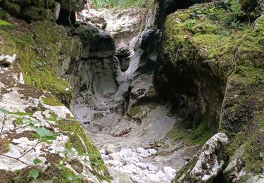
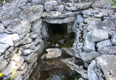
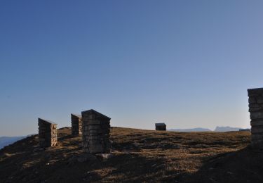
On commence par 3 ou 400m de route interdite à la circulation pour accéder à la « maison forestière de Pré Grandu ». De là un chemin va nous conduire à la « Nouvelle Jasse de la Chau » (deux cabanes). Ensuite on attaque une traversée nord-sud sous le « grand Veymont ». A partir de la « Fontaine des Serrons » (une à deux heures pour remplir une bouteille) on quitte le GR91 pour un sentier peu visible et qui ne figure qu’en partie sur la carte (GPS très utile). Sur le terrain il est toutefois balisé par des cairns jusqu’à proximité du « Pas de Chatons ». On poursuit la montée vers le « Pas des Bachassons » point culminant de la rando. On va poursuivre par la « Plaine de la Queyrie » et son remarquable « Arbre Taillé » et sa « Carrière Romaine ». Non loin de la « Cabane de Pré Peyret », on reprend le GR91 que l’on quittera au milieu de la forêt pour rejoindre « Pré Grandu » et le point de départ en passant par « Gerland » et la « route du Rachier ».

Elevation profile

Points of interest

Point of interest Saint-Agnan-en-Vercors -  - Photo
Alfredy
SAINT-AGNAN-EN-VERCORS 
Point of interest Gresse-en-Vercors -  - Photo
Alfredy
GRESSE-EN-VERCORS 
Point of interest Gresse-en-Vercors -  - Photo
Alfredy
GRESSE-EN-VERCORS 
Point of interest Saint-Agnan-en-Vercors -  - Photo
Alfredy
SAINT-AGNAN-EN-VERCORS 

Positioning

Country:
France
Region :
Auvergne-Rhône-Alpes
Department/Province :
Drôme
Municipality :
Saint-Agnan-en-Vercors
Location:
Unknown
Start:(UTM)
692904 ; 4973136 (31T) N.

Comments

Please log in to post a review or rate the element


Trails nearby

Trail Snowshoes Saint-Agnan-en-Vercors - Rousset-Plateau de Beure 7,5km - Photo
Snowshoes
GUIDE
thonyc

Snowshoes

Medium
Saint-Agnan-en-Vercors, Auvergne-Rhône-Alpes, Drôme, France
7.3 km | 11.5 km-effort
4h 30min
Yes
Trail Walking Saint-Agnan-en-Vercors - Les Hauts Plateaux du Vercors - Photo
Walking
Greg813

Walking

Difficult
Saint-Agnan-en-Vercors, Auvergne-Rhône-Alpes, Drôme, France
12 km | 19.1 km-effort
3h 51min
Yes
Trail Walking Saint-Agnan-en-Vercors - 26 tiolache - Photo
Walking
himba26100

Walking

Easy
Saint-Agnan-en-Vercors, Auvergne-Rhône-Alpes, Drôme, France
14.4 km | 21 km-effort
6h 13min
Yes
Trail Snowshoes Saint-Agnan-en-Vercors - plateau de beure - Photo
Snowshoes
TOULAUDIN

Snowshoes

Medium
Saint-Agnan-en-Vercors, Auvergne-Rhône-Alpes, Drôme, France
12.1 km | 18.6 km-effort
6h 14min
Yes
Trail Walking Saint-Agnan-en-Vercors - Rando ASPTT Pas des Econdus Pas  de Chabrinel - Photo
Walking
TOULAUDIN

Walking

Difficult
Saint-Agnan-en-Vercors, Auvergne-Rhône-Alpes, Drôme, France
13.6 km | 23 km-effort
6h 20min
Yes
Trail Walking Saint-Agnan-en-Vercors - trop Alexis - Photo
Walking
jphugon

Walking

Very difficult
Saint-Agnan-en-Vercors, Auvergne-Rhône-Alpes, Drôme, France
16.3 km | 28 km-effort
7h 59min
Yes
Trail Walking Saint-Agnan-en-Vercors - Malaval  - Photo
Walking
ajd26

Walking

Very difficult
Saint-Agnan-en-Vercors, Auvergne-Rhône-Alpes, Drôme, France
14.6 km | 24 km-effort
5h 49min
Yes
Trail Walking Vassieux-en-Vercors - Vassieux en Vercors- La Chapelle en Vercors- Rando Âne (2 et 3 ème jour) -  - Photo
Walking
crocau

Walking

Easy
Vassieux-en-Vercors, Auvergne-Rhône-Alpes, Drôme, France
15.4 km | 19.3 km-effort
5h 11min
No
Trail Walking Saint-Agnan-en-Vercors - Montagne de Beure et But Sapiau - Photo
Walking
crocau

Walking

Difficult
Saint-Agnan-en-Vercors, Auvergne-Rhône-Alpes, Drôme, France
7.6 km | 12.1 km-effort
2h 59min
Yes


Close
My subscriptions