


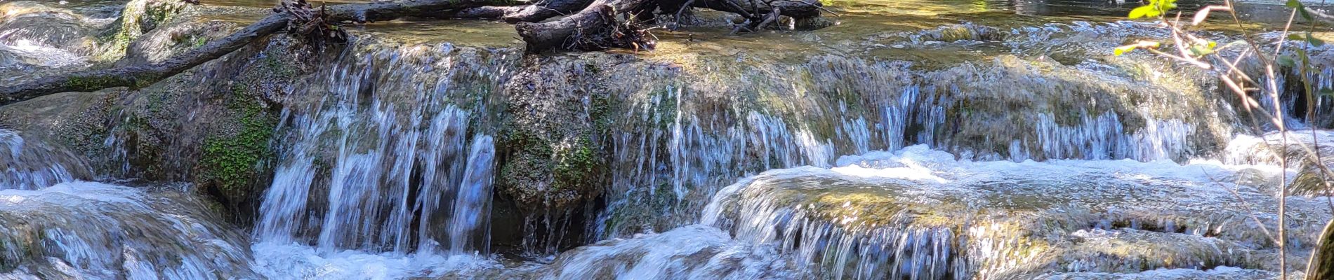
"Les sources de l'Ubelka"

mb83serre
User GUIDE
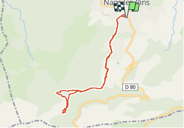

Length
9.3 km

Max alt
487 m

Uphill gradient
224 m
Km-Effort
12.3 km

Min alt
394 m

Downhill gradient
223 m
Boucle
Yes
Creation date :
2025-03-26 08:02:26.871
Updated on :
2025-03-26 15:44:46.336
3h59
Difficulty : Medium

FREE GPS app for hiking
 SityTrail
IGN / Geographical institutes
SityTrail Plus
The world is yours!
About
Trail Walking of 9.3 km to be discovered at Provence-Alpes-Côte d'Azur, Var, Nans-les-Pins. This trail is proposed by mb83serre.
Description
Possibilité de faire en plus :
La grotte Sainte-marie-Madeleine
ou simplement la grotte de Castelette
Photos
"
data-pinterest-text="Pin it"
data-tweet-text="share on twitter"
data-facebook-share-url="https://www.sitytrail.com/en/trails/4398042-nansxlesxpins--xles-sources-de-lxubelkax/?photo=0#lg=1&slide=0"
data-twitter-share-url="https://www.sitytrail.com/en/trails/4398042-nansxlesxpins--xles-sources-de-lxubelkax/?photo=0#lg=1&slide=0"
data-googleplus-share-url="https://www.sitytrail.com/en/trails/4398042-nansxlesxpins--xles-sources-de-lxubelkax/?photo=0#lg=1&slide=0"
data-pinterest-share-url="https://www.sitytrail.com/en/trails/4398042-nansxlesxpins--xles-sources-de-lxubelkax/?photo=0#lg=1&slide=0">
 "
data-pinterest-text="Pin it"
data-tweet-text="share on twitter"
data-facebook-share-url="https://www.sitytrail.com/en/trails/4398042-nansxlesxpins--xles-sources-de-lxubelkax/?photo=1#lg=1&slide=1"
data-twitter-share-url="https://www.sitytrail.com/en/trails/4398042-nansxlesxpins--xles-sources-de-lxubelkax/?photo=1#lg=1&slide=1"
data-googleplus-share-url="https://www.sitytrail.com/en/trails/4398042-nansxlesxpins--xles-sources-de-lxubelkax/?photo=1#lg=1&slide=1"
data-pinterest-share-url="https://www.sitytrail.com/en/trails/4398042-nansxlesxpins--xles-sources-de-lxubelkax/?photo=1#lg=1&slide=1">
"
data-pinterest-text="Pin it"
data-tweet-text="share on twitter"
data-facebook-share-url="https://www.sitytrail.com/en/trails/4398042-nansxlesxpins--xles-sources-de-lxubelkax/?photo=1#lg=1&slide=1"
data-twitter-share-url="https://www.sitytrail.com/en/trails/4398042-nansxlesxpins--xles-sources-de-lxubelkax/?photo=1#lg=1&slide=1"
data-googleplus-share-url="https://www.sitytrail.com/en/trails/4398042-nansxlesxpins--xles-sources-de-lxubelkax/?photo=1#lg=1&slide=1"
data-pinterest-share-url="https://www.sitytrail.com/en/trails/4398042-nansxlesxpins--xles-sources-de-lxubelkax/?photo=1#lg=1&slide=1">
 "
data-pinterest-text="Pin it"
data-tweet-text="share on twitter"
data-facebook-share-url="https://www.sitytrail.com/en/trails/4398042-nansxlesxpins--xles-sources-de-lxubelkax/?photo=2#lg=1&slide=2"
data-twitter-share-url="https://www.sitytrail.com/en/trails/4398042-nansxlesxpins--xles-sources-de-lxubelkax/?photo=2#lg=1&slide=2"
data-googleplus-share-url="https://www.sitytrail.com/en/trails/4398042-nansxlesxpins--xles-sources-de-lxubelkax/?photo=2#lg=1&slide=2"
data-pinterest-share-url="https://www.sitytrail.com/en/trails/4398042-nansxlesxpins--xles-sources-de-lxubelkax/?photo=2#lg=1&slide=2">
"
data-pinterest-text="Pin it"
data-tweet-text="share on twitter"
data-facebook-share-url="https://www.sitytrail.com/en/trails/4398042-nansxlesxpins--xles-sources-de-lxubelkax/?photo=2#lg=1&slide=2"
data-twitter-share-url="https://www.sitytrail.com/en/trails/4398042-nansxlesxpins--xles-sources-de-lxubelkax/?photo=2#lg=1&slide=2"
data-googleplus-share-url="https://www.sitytrail.com/en/trails/4398042-nansxlesxpins--xles-sources-de-lxubelkax/?photo=2#lg=1&slide=2"
data-pinterest-share-url="https://www.sitytrail.com/en/trails/4398042-nansxlesxpins--xles-sources-de-lxubelkax/?photo=2#lg=1&slide=2">
 "
data-pinterest-text="Pin it"
data-tweet-text="share on twitter"
data-facebook-share-url="https://www.sitytrail.com/en/trails/4398042-nansxlesxpins--xles-sources-de-lxubelkax/?photo=3#lg=1&slide=3"
data-twitter-share-url="https://www.sitytrail.com/en/trails/4398042-nansxlesxpins--xles-sources-de-lxubelkax/?photo=3#lg=1&slide=3"
data-googleplus-share-url="https://www.sitytrail.com/en/trails/4398042-nansxlesxpins--xles-sources-de-lxubelkax/?photo=3#lg=1&slide=3"
data-pinterest-share-url="https://www.sitytrail.com/en/trails/4398042-nansxlesxpins--xles-sources-de-lxubelkax/?photo=3#lg=1&slide=3">
"
data-pinterest-text="Pin it"
data-tweet-text="share on twitter"
data-facebook-share-url="https://www.sitytrail.com/en/trails/4398042-nansxlesxpins--xles-sources-de-lxubelkax/?photo=3#lg=1&slide=3"
data-twitter-share-url="https://www.sitytrail.com/en/trails/4398042-nansxlesxpins--xles-sources-de-lxubelkax/?photo=3#lg=1&slide=3"
data-googleplus-share-url="https://www.sitytrail.com/en/trails/4398042-nansxlesxpins--xles-sources-de-lxubelkax/?photo=3#lg=1&slide=3"
data-pinterest-share-url="https://www.sitytrail.com/en/trails/4398042-nansxlesxpins--xles-sources-de-lxubelkax/?photo=3#lg=1&slide=3">
 "
data-pinterest-text="Pin it"
data-tweet-text="share on twitter"
data-facebook-share-url="https://www.sitytrail.com/en/trails/4398042-nansxlesxpins--xles-sources-de-lxubelkax/?photo=4#lg=1&slide=4"
data-twitter-share-url="https://www.sitytrail.com/en/trails/4398042-nansxlesxpins--xles-sources-de-lxubelkax/?photo=4#lg=1&slide=4"
data-googleplus-share-url="https://www.sitytrail.com/en/trails/4398042-nansxlesxpins--xles-sources-de-lxubelkax/?photo=4#lg=1&slide=4"
data-pinterest-share-url="https://www.sitytrail.com/en/trails/4398042-nansxlesxpins--xles-sources-de-lxubelkax/?photo=4#lg=1&slide=4">
"
data-pinterest-text="Pin it"
data-tweet-text="share on twitter"
data-facebook-share-url="https://www.sitytrail.com/en/trails/4398042-nansxlesxpins--xles-sources-de-lxubelkax/?photo=4#lg=1&slide=4"
data-twitter-share-url="https://www.sitytrail.com/en/trails/4398042-nansxlesxpins--xles-sources-de-lxubelkax/?photo=4#lg=1&slide=4"
data-googleplus-share-url="https://www.sitytrail.com/en/trails/4398042-nansxlesxpins--xles-sources-de-lxubelkax/?photo=4#lg=1&slide=4"
data-pinterest-share-url="https://www.sitytrail.com/en/trails/4398042-nansxlesxpins--xles-sources-de-lxubelkax/?photo=4#lg=1&slide=4">
 "
data-pinterest-text="Pin it"
data-tweet-text="share on twitter"
data-facebook-share-url="https://www.sitytrail.com/en/trails/4398042-nansxlesxpins--xles-sources-de-lxubelkax/?photo=5#lg=1&slide=5"
data-twitter-share-url="https://www.sitytrail.com/en/trails/4398042-nansxlesxpins--xles-sources-de-lxubelkax/?photo=5#lg=1&slide=5"
data-googleplus-share-url="https://www.sitytrail.com/en/trails/4398042-nansxlesxpins--xles-sources-de-lxubelkax/?photo=5#lg=1&slide=5"
data-pinterest-share-url="https://www.sitytrail.com/en/trails/4398042-nansxlesxpins--xles-sources-de-lxubelkax/?photo=5#lg=1&slide=5">
"
data-pinterest-text="Pin it"
data-tweet-text="share on twitter"
data-facebook-share-url="https://www.sitytrail.com/en/trails/4398042-nansxlesxpins--xles-sources-de-lxubelkax/?photo=5#lg=1&slide=5"
data-twitter-share-url="https://www.sitytrail.com/en/trails/4398042-nansxlesxpins--xles-sources-de-lxubelkax/?photo=5#lg=1&slide=5"
data-googleplus-share-url="https://www.sitytrail.com/en/trails/4398042-nansxlesxpins--xles-sources-de-lxubelkax/?photo=5#lg=1&slide=5"
data-pinterest-share-url="https://www.sitytrail.com/en/trails/4398042-nansxlesxpins--xles-sources-de-lxubelkax/?photo=5#lg=1&slide=5">
 "
data-pinterest-text="Pin it"
data-tweet-text="share on twitter"
data-facebook-share-url="https://www.sitytrail.com/en/trails/4398042-nansxlesxpins--xles-sources-de-lxubelkax/?photo=6#lg=1&slide=6"
data-twitter-share-url="https://www.sitytrail.com/en/trails/4398042-nansxlesxpins--xles-sources-de-lxubelkax/?photo=6#lg=1&slide=6"
data-googleplus-share-url="https://www.sitytrail.com/en/trails/4398042-nansxlesxpins--xles-sources-de-lxubelkax/?photo=6#lg=1&slide=6"
data-pinterest-share-url="https://www.sitytrail.com/en/trails/4398042-nansxlesxpins--xles-sources-de-lxubelkax/?photo=6#lg=1&slide=6">
"
data-pinterest-text="Pin it"
data-tweet-text="share on twitter"
data-facebook-share-url="https://www.sitytrail.com/en/trails/4398042-nansxlesxpins--xles-sources-de-lxubelkax/?photo=6#lg=1&slide=6"
data-twitter-share-url="https://www.sitytrail.com/en/trails/4398042-nansxlesxpins--xles-sources-de-lxubelkax/?photo=6#lg=1&slide=6"
data-googleplus-share-url="https://www.sitytrail.com/en/trails/4398042-nansxlesxpins--xles-sources-de-lxubelkax/?photo=6#lg=1&slide=6"
data-pinterest-share-url="https://www.sitytrail.com/en/trails/4398042-nansxlesxpins--xles-sources-de-lxubelkax/?photo=6#lg=1&slide=6">
 "
data-pinterest-text="Pin it"
data-tweet-text="share on twitter"
data-facebook-share-url="https://www.sitytrail.com/en/trails/4398042-nansxlesxpins--xles-sources-de-lxubelkax/?photo=7#lg=1&slide=7"
data-twitter-share-url="https://www.sitytrail.com/en/trails/4398042-nansxlesxpins--xles-sources-de-lxubelkax/?photo=7#lg=1&slide=7"
data-googleplus-share-url="https://www.sitytrail.com/en/trails/4398042-nansxlesxpins--xles-sources-de-lxubelkax/?photo=7#lg=1&slide=7"
data-pinterest-share-url="https://www.sitytrail.com/en/trails/4398042-nansxlesxpins--xles-sources-de-lxubelkax/?photo=7#lg=1&slide=7">
"
data-pinterest-text="Pin it"
data-tweet-text="share on twitter"
data-facebook-share-url="https://www.sitytrail.com/en/trails/4398042-nansxlesxpins--xles-sources-de-lxubelkax/?photo=7#lg=1&slide=7"
data-twitter-share-url="https://www.sitytrail.com/en/trails/4398042-nansxlesxpins--xles-sources-de-lxubelkax/?photo=7#lg=1&slide=7"
data-googleplus-share-url="https://www.sitytrail.com/en/trails/4398042-nansxlesxpins--xles-sources-de-lxubelkax/?photo=7#lg=1&slide=7"
data-pinterest-share-url="https://www.sitytrail.com/en/trails/4398042-nansxlesxpins--xles-sources-de-lxubelkax/?photo=7#lg=1&slide=7">
 "
data-pinterest-text="Pin it"
data-tweet-text="share on twitter"
data-facebook-share-url="https://www.sitytrail.com/en/trails/4398042-nansxlesxpins--xles-sources-de-lxubelkax/?photo=8#lg=1&slide=8"
data-twitter-share-url="https://www.sitytrail.com/en/trails/4398042-nansxlesxpins--xles-sources-de-lxubelkax/?photo=8#lg=1&slide=8"
data-googleplus-share-url="https://www.sitytrail.com/en/trails/4398042-nansxlesxpins--xles-sources-de-lxubelkax/?photo=8#lg=1&slide=8"
data-pinterest-share-url="https://www.sitytrail.com/en/trails/4398042-nansxlesxpins--xles-sources-de-lxubelkax/?photo=8#lg=1&slide=8">
"
data-pinterest-text="Pin it"
data-tweet-text="share on twitter"
data-facebook-share-url="https://www.sitytrail.com/en/trails/4398042-nansxlesxpins--xles-sources-de-lxubelkax/?photo=8#lg=1&slide=8"
data-twitter-share-url="https://www.sitytrail.com/en/trails/4398042-nansxlesxpins--xles-sources-de-lxubelkax/?photo=8#lg=1&slide=8"
data-googleplus-share-url="https://www.sitytrail.com/en/trails/4398042-nansxlesxpins--xles-sources-de-lxubelkax/?photo=8#lg=1&slide=8"
data-pinterest-share-url="https://www.sitytrail.com/en/trails/4398042-nansxlesxpins--xles-sources-de-lxubelkax/?photo=8#lg=1&slide=8">
 "
data-pinterest-text="Pin it"
data-tweet-text="share on twitter"
data-facebook-share-url="https://www.sitytrail.com/en/trails/4398042-nansxlesxpins--xles-sources-de-lxubelkax/?photo=9#lg=1&slide=9"
data-twitter-share-url="https://www.sitytrail.com/en/trails/4398042-nansxlesxpins--xles-sources-de-lxubelkax/?photo=9#lg=1&slide=9"
data-googleplus-share-url="https://www.sitytrail.com/en/trails/4398042-nansxlesxpins--xles-sources-de-lxubelkax/?photo=9#lg=1&slide=9"
data-pinterest-share-url="https://www.sitytrail.com/en/trails/4398042-nansxlesxpins--xles-sources-de-lxubelkax/?photo=9#lg=1&slide=9">
"
data-pinterest-text="Pin it"
data-tweet-text="share on twitter"
data-facebook-share-url="https://www.sitytrail.com/en/trails/4398042-nansxlesxpins--xles-sources-de-lxubelkax/?photo=9#lg=1&slide=9"
data-twitter-share-url="https://www.sitytrail.com/en/trails/4398042-nansxlesxpins--xles-sources-de-lxubelkax/?photo=9#lg=1&slide=9"
data-googleplus-share-url="https://www.sitytrail.com/en/trails/4398042-nansxlesxpins--xles-sources-de-lxubelkax/?photo=9#lg=1&slide=9"
data-pinterest-share-url="https://www.sitytrail.com/en/trails/4398042-nansxlesxpins--xles-sources-de-lxubelkax/?photo=9#lg=1&slide=9">
 "
data-pinterest-text="Pin it"
data-tweet-text="share on twitter"
data-facebook-share-url="https://www.sitytrail.com/en/trails/4398042-nansxlesxpins--xles-sources-de-lxubelkax/?photo=10#lg=1&slide=10"
data-twitter-share-url="https://www.sitytrail.com/en/trails/4398042-nansxlesxpins--xles-sources-de-lxubelkax/?photo=10#lg=1&slide=10"
data-googleplus-share-url="https://www.sitytrail.com/en/trails/4398042-nansxlesxpins--xles-sources-de-lxubelkax/?photo=10#lg=1&slide=10"
data-pinterest-share-url="https://www.sitytrail.com/en/trails/4398042-nansxlesxpins--xles-sources-de-lxubelkax/?photo=10#lg=1&slide=10">
"
data-pinterest-text="Pin it"
data-tweet-text="share on twitter"
data-facebook-share-url="https://www.sitytrail.com/en/trails/4398042-nansxlesxpins--xles-sources-de-lxubelkax/?photo=10#lg=1&slide=10"
data-twitter-share-url="https://www.sitytrail.com/en/trails/4398042-nansxlesxpins--xles-sources-de-lxubelkax/?photo=10#lg=1&slide=10"
data-googleplus-share-url="https://www.sitytrail.com/en/trails/4398042-nansxlesxpins--xles-sources-de-lxubelkax/?photo=10#lg=1&slide=10"
data-pinterest-share-url="https://www.sitytrail.com/en/trails/4398042-nansxlesxpins--xles-sources-de-lxubelkax/?photo=10#lg=1&slide=10">
 "
data-pinterest-text="Pin it"
data-tweet-text="share on twitter"
data-facebook-share-url="https://www.sitytrail.com/en/trails/4398042-nansxlesxpins--xles-sources-de-lxubelkax/?photo=11#lg=1&slide=11"
data-twitter-share-url="https://www.sitytrail.com/en/trails/4398042-nansxlesxpins--xles-sources-de-lxubelkax/?photo=11#lg=1&slide=11"
data-googleplus-share-url="https://www.sitytrail.com/en/trails/4398042-nansxlesxpins--xles-sources-de-lxubelkax/?photo=11#lg=1&slide=11"
data-pinterest-share-url="https://www.sitytrail.com/en/trails/4398042-nansxlesxpins--xles-sources-de-lxubelkax/?photo=11#lg=1&slide=11">
"
data-pinterest-text="Pin it"
data-tweet-text="share on twitter"
data-facebook-share-url="https://www.sitytrail.com/en/trails/4398042-nansxlesxpins--xles-sources-de-lxubelkax/?photo=11#lg=1&slide=11"
data-twitter-share-url="https://www.sitytrail.com/en/trails/4398042-nansxlesxpins--xles-sources-de-lxubelkax/?photo=11#lg=1&slide=11"
data-googleplus-share-url="https://www.sitytrail.com/en/trails/4398042-nansxlesxpins--xles-sources-de-lxubelkax/?photo=11#lg=1&slide=11"
data-pinterest-share-url="https://www.sitytrail.com/en/trails/4398042-nansxlesxpins--xles-sources-de-lxubelkax/?photo=11#lg=1&slide=11">
 "
data-pinterest-text="Pin it"
data-tweet-text="share on twitter"
data-facebook-share-url="https://www.sitytrail.com/en/trails/4398042-nansxlesxpins--xles-sources-de-lxubelkax/?photo=12#lg=1&slide=12"
data-twitter-share-url="https://www.sitytrail.com/en/trails/4398042-nansxlesxpins--xles-sources-de-lxubelkax/?photo=12#lg=1&slide=12"
data-googleplus-share-url="https://www.sitytrail.com/en/trails/4398042-nansxlesxpins--xles-sources-de-lxubelkax/?photo=12#lg=1&slide=12"
data-pinterest-share-url="https://www.sitytrail.com/en/trails/4398042-nansxlesxpins--xles-sources-de-lxubelkax/?photo=12#lg=1&slide=12">
"
data-pinterest-text="Pin it"
data-tweet-text="share on twitter"
data-facebook-share-url="https://www.sitytrail.com/en/trails/4398042-nansxlesxpins--xles-sources-de-lxubelkax/?photo=12#lg=1&slide=12"
data-twitter-share-url="https://www.sitytrail.com/en/trails/4398042-nansxlesxpins--xles-sources-de-lxubelkax/?photo=12#lg=1&slide=12"
data-googleplus-share-url="https://www.sitytrail.com/en/trails/4398042-nansxlesxpins--xles-sources-de-lxubelkax/?photo=12#lg=1&slide=12"
data-pinterest-share-url="https://www.sitytrail.com/en/trails/4398042-nansxlesxpins--xles-sources-de-lxubelkax/?photo=12#lg=1&slide=12">
 "
data-pinterest-text="Pin it"
data-tweet-text="share on twitter"
data-facebook-share-url="https://www.sitytrail.com/en/trails/4398042-nansxlesxpins--xles-sources-de-lxubelkax/?photo=13#lg=1&slide=13"
data-twitter-share-url="https://www.sitytrail.com/en/trails/4398042-nansxlesxpins--xles-sources-de-lxubelkax/?photo=13#lg=1&slide=13"
data-googleplus-share-url="https://www.sitytrail.com/en/trails/4398042-nansxlesxpins--xles-sources-de-lxubelkax/?photo=13#lg=1&slide=13"
data-pinterest-share-url="https://www.sitytrail.com/en/trails/4398042-nansxlesxpins--xles-sources-de-lxubelkax/?photo=13#lg=1&slide=13">
"
data-pinterest-text="Pin it"
data-tweet-text="share on twitter"
data-facebook-share-url="https://www.sitytrail.com/en/trails/4398042-nansxlesxpins--xles-sources-de-lxubelkax/?photo=13#lg=1&slide=13"
data-twitter-share-url="https://www.sitytrail.com/en/trails/4398042-nansxlesxpins--xles-sources-de-lxubelkax/?photo=13#lg=1&slide=13"
data-googleplus-share-url="https://www.sitytrail.com/en/trails/4398042-nansxlesxpins--xles-sources-de-lxubelkax/?photo=13#lg=1&slide=13"
data-pinterest-share-url="https://www.sitytrail.com/en/trails/4398042-nansxlesxpins--xles-sources-de-lxubelkax/?photo=13#lg=1&slide=13">
 "
data-pinterest-text="Pin it"
data-tweet-text="share on twitter"
data-facebook-share-url="https://www.sitytrail.com/en/trails/4398042-nansxlesxpins--xles-sources-de-lxubelkax/?photo=14#lg=1&slide=14"
data-twitter-share-url="https://www.sitytrail.com/en/trails/4398042-nansxlesxpins--xles-sources-de-lxubelkax/?photo=14#lg=1&slide=14"
data-googleplus-share-url="https://www.sitytrail.com/en/trails/4398042-nansxlesxpins--xles-sources-de-lxubelkax/?photo=14#lg=1&slide=14"
data-pinterest-share-url="https://www.sitytrail.com/en/trails/4398042-nansxlesxpins--xles-sources-de-lxubelkax/?photo=14#lg=1&slide=14">
"
data-pinterest-text="Pin it"
data-tweet-text="share on twitter"
data-facebook-share-url="https://www.sitytrail.com/en/trails/4398042-nansxlesxpins--xles-sources-de-lxubelkax/?photo=14#lg=1&slide=14"
data-twitter-share-url="https://www.sitytrail.com/en/trails/4398042-nansxlesxpins--xles-sources-de-lxubelkax/?photo=14#lg=1&slide=14"
data-googleplus-share-url="https://www.sitytrail.com/en/trails/4398042-nansxlesxpins--xles-sources-de-lxubelkax/?photo=14#lg=1&slide=14"
data-pinterest-share-url="https://www.sitytrail.com/en/trails/4398042-nansxlesxpins--xles-sources-de-lxubelkax/?photo=14#lg=1&slide=14">
 "
data-pinterest-text="Pin it"
data-tweet-text="share on twitter"
data-facebook-share-url="https://www.sitytrail.com/en/trails/4398042-nansxlesxpins--xles-sources-de-lxubelkax/?photo=15#lg=1&slide=15"
data-twitter-share-url="https://www.sitytrail.com/en/trails/4398042-nansxlesxpins--xles-sources-de-lxubelkax/?photo=15#lg=1&slide=15"
data-googleplus-share-url="https://www.sitytrail.com/en/trails/4398042-nansxlesxpins--xles-sources-de-lxubelkax/?photo=15#lg=1&slide=15"
data-pinterest-share-url="https://www.sitytrail.com/en/trails/4398042-nansxlesxpins--xles-sources-de-lxubelkax/?photo=15#lg=1&slide=15">
"
data-pinterest-text="Pin it"
data-tweet-text="share on twitter"
data-facebook-share-url="https://www.sitytrail.com/en/trails/4398042-nansxlesxpins--xles-sources-de-lxubelkax/?photo=15#lg=1&slide=15"
data-twitter-share-url="https://www.sitytrail.com/en/trails/4398042-nansxlesxpins--xles-sources-de-lxubelkax/?photo=15#lg=1&slide=15"
data-googleplus-share-url="https://www.sitytrail.com/en/trails/4398042-nansxlesxpins--xles-sources-de-lxubelkax/?photo=15#lg=1&slide=15"
data-pinterest-share-url="https://www.sitytrail.com/en/trails/4398042-nansxlesxpins--xles-sources-de-lxubelkax/?photo=15#lg=1&slide=15">
 "
data-pinterest-text="Pin it"
data-tweet-text="share on twitter"
data-facebook-share-url="https://www.sitytrail.com/en/trails/4398042-nansxlesxpins--xles-sources-de-lxubelkax/?photo=16#lg=1&slide=16"
data-twitter-share-url="https://www.sitytrail.com/en/trails/4398042-nansxlesxpins--xles-sources-de-lxubelkax/?photo=16#lg=1&slide=16"
data-googleplus-share-url="https://www.sitytrail.com/en/trails/4398042-nansxlesxpins--xles-sources-de-lxubelkax/?photo=16#lg=1&slide=16"
data-pinterest-share-url="https://www.sitytrail.com/en/trails/4398042-nansxlesxpins--xles-sources-de-lxubelkax/?photo=16#lg=1&slide=16">
"
data-pinterest-text="Pin it"
data-tweet-text="share on twitter"
data-facebook-share-url="https://www.sitytrail.com/en/trails/4398042-nansxlesxpins--xles-sources-de-lxubelkax/?photo=16#lg=1&slide=16"
data-twitter-share-url="https://www.sitytrail.com/en/trails/4398042-nansxlesxpins--xles-sources-de-lxubelkax/?photo=16#lg=1&slide=16"
data-googleplus-share-url="https://www.sitytrail.com/en/trails/4398042-nansxlesxpins--xles-sources-de-lxubelkax/?photo=16#lg=1&slide=16"
data-pinterest-share-url="https://www.sitytrail.com/en/trails/4398042-nansxlesxpins--xles-sources-de-lxubelkax/?photo=16#lg=1&slide=16">
 "
data-pinterest-text="Pin it"
data-tweet-text="share on twitter"
data-facebook-share-url="https://www.sitytrail.com/en/trails/4398042-nansxlesxpins--xles-sources-de-lxubelkax/?photo=17#lg=1&slide=17"
data-twitter-share-url="https://www.sitytrail.com/en/trails/4398042-nansxlesxpins--xles-sources-de-lxubelkax/?photo=17#lg=1&slide=17"
data-googleplus-share-url="https://www.sitytrail.com/en/trails/4398042-nansxlesxpins--xles-sources-de-lxubelkax/?photo=17#lg=1&slide=17"
data-pinterest-share-url="https://www.sitytrail.com/en/trails/4398042-nansxlesxpins--xles-sources-de-lxubelkax/?photo=17#lg=1&slide=17">
"
data-pinterest-text="Pin it"
data-tweet-text="share on twitter"
data-facebook-share-url="https://www.sitytrail.com/en/trails/4398042-nansxlesxpins--xles-sources-de-lxubelkax/?photo=17#lg=1&slide=17"
data-twitter-share-url="https://www.sitytrail.com/en/trails/4398042-nansxlesxpins--xles-sources-de-lxubelkax/?photo=17#lg=1&slide=17"
data-googleplus-share-url="https://www.sitytrail.com/en/trails/4398042-nansxlesxpins--xles-sources-de-lxubelkax/?photo=17#lg=1&slide=17"
data-pinterest-share-url="https://www.sitytrail.com/en/trails/4398042-nansxlesxpins--xles-sources-de-lxubelkax/?photo=17#lg=1&slide=17">
 "
data-pinterest-text="Pin it"
data-tweet-text="share on twitter"
data-facebook-share-url="https://www.sitytrail.com/en/trails/4398042-nansxlesxpins--xles-sources-de-lxubelkax/?photo=18#lg=1&slide=18"
data-twitter-share-url="https://www.sitytrail.com/en/trails/4398042-nansxlesxpins--xles-sources-de-lxubelkax/?photo=18#lg=1&slide=18"
data-googleplus-share-url="https://www.sitytrail.com/en/trails/4398042-nansxlesxpins--xles-sources-de-lxubelkax/?photo=18#lg=1&slide=18"
data-pinterest-share-url="https://www.sitytrail.com/en/trails/4398042-nansxlesxpins--xles-sources-de-lxubelkax/?photo=18#lg=1&slide=18">
"
data-pinterest-text="Pin it"
data-tweet-text="share on twitter"
data-facebook-share-url="https://www.sitytrail.com/en/trails/4398042-nansxlesxpins--xles-sources-de-lxubelkax/?photo=18#lg=1&slide=18"
data-twitter-share-url="https://www.sitytrail.com/en/trails/4398042-nansxlesxpins--xles-sources-de-lxubelkax/?photo=18#lg=1&slide=18"
data-googleplus-share-url="https://www.sitytrail.com/en/trails/4398042-nansxlesxpins--xles-sources-de-lxubelkax/?photo=18#lg=1&slide=18"
data-pinterest-share-url="https://www.sitytrail.com/en/trails/4398042-nansxlesxpins--xles-sources-de-lxubelkax/?photo=18#lg=1&slide=18">

 "
data-pinterest-text="Pin it"
data-tweet-text="share on twitter"
data-facebook-share-url="https://www.sitytrail.com/en/trails/4398042-nansxlesxpins--xles-sources-de-lxubelkax/?photo=1#lg=1&slide=1"
data-twitter-share-url="https://www.sitytrail.com/en/trails/4398042-nansxlesxpins--xles-sources-de-lxubelkax/?photo=1#lg=1&slide=1"
data-googleplus-share-url="https://www.sitytrail.com/en/trails/4398042-nansxlesxpins--xles-sources-de-lxubelkax/?photo=1#lg=1&slide=1"
data-pinterest-share-url="https://www.sitytrail.com/en/trails/4398042-nansxlesxpins--xles-sources-de-lxubelkax/?photo=1#lg=1&slide=1">
"
data-pinterest-text="Pin it"
data-tweet-text="share on twitter"
data-facebook-share-url="https://www.sitytrail.com/en/trails/4398042-nansxlesxpins--xles-sources-de-lxubelkax/?photo=1#lg=1&slide=1"
data-twitter-share-url="https://www.sitytrail.com/en/trails/4398042-nansxlesxpins--xles-sources-de-lxubelkax/?photo=1#lg=1&slide=1"
data-googleplus-share-url="https://www.sitytrail.com/en/trails/4398042-nansxlesxpins--xles-sources-de-lxubelkax/?photo=1#lg=1&slide=1"
data-pinterest-share-url="https://www.sitytrail.com/en/trails/4398042-nansxlesxpins--xles-sources-de-lxubelkax/?photo=1#lg=1&slide=1">
 "
data-pinterest-text="Pin it"
data-tweet-text="share on twitter"
data-facebook-share-url="https://www.sitytrail.com/en/trails/4398042-nansxlesxpins--xles-sources-de-lxubelkax/?photo=2#lg=1&slide=2"
data-twitter-share-url="https://www.sitytrail.com/en/trails/4398042-nansxlesxpins--xles-sources-de-lxubelkax/?photo=2#lg=1&slide=2"
data-googleplus-share-url="https://www.sitytrail.com/en/trails/4398042-nansxlesxpins--xles-sources-de-lxubelkax/?photo=2#lg=1&slide=2"
data-pinterest-share-url="https://www.sitytrail.com/en/trails/4398042-nansxlesxpins--xles-sources-de-lxubelkax/?photo=2#lg=1&slide=2">
"
data-pinterest-text="Pin it"
data-tweet-text="share on twitter"
data-facebook-share-url="https://www.sitytrail.com/en/trails/4398042-nansxlesxpins--xles-sources-de-lxubelkax/?photo=2#lg=1&slide=2"
data-twitter-share-url="https://www.sitytrail.com/en/trails/4398042-nansxlesxpins--xles-sources-de-lxubelkax/?photo=2#lg=1&slide=2"
data-googleplus-share-url="https://www.sitytrail.com/en/trails/4398042-nansxlesxpins--xles-sources-de-lxubelkax/?photo=2#lg=1&slide=2"
data-pinterest-share-url="https://www.sitytrail.com/en/trails/4398042-nansxlesxpins--xles-sources-de-lxubelkax/?photo=2#lg=1&slide=2">
 "
data-pinterest-text="Pin it"
data-tweet-text="share on twitter"
data-facebook-share-url="https://www.sitytrail.com/en/trails/4398042-nansxlesxpins--xles-sources-de-lxubelkax/?photo=3#lg=1&slide=3"
data-twitter-share-url="https://www.sitytrail.com/en/trails/4398042-nansxlesxpins--xles-sources-de-lxubelkax/?photo=3#lg=1&slide=3"
data-googleplus-share-url="https://www.sitytrail.com/en/trails/4398042-nansxlesxpins--xles-sources-de-lxubelkax/?photo=3#lg=1&slide=3"
data-pinterest-share-url="https://www.sitytrail.com/en/trails/4398042-nansxlesxpins--xles-sources-de-lxubelkax/?photo=3#lg=1&slide=3">
"
data-pinterest-text="Pin it"
data-tweet-text="share on twitter"
data-facebook-share-url="https://www.sitytrail.com/en/trails/4398042-nansxlesxpins--xles-sources-de-lxubelkax/?photo=3#lg=1&slide=3"
data-twitter-share-url="https://www.sitytrail.com/en/trails/4398042-nansxlesxpins--xles-sources-de-lxubelkax/?photo=3#lg=1&slide=3"
data-googleplus-share-url="https://www.sitytrail.com/en/trails/4398042-nansxlesxpins--xles-sources-de-lxubelkax/?photo=3#lg=1&slide=3"
data-pinterest-share-url="https://www.sitytrail.com/en/trails/4398042-nansxlesxpins--xles-sources-de-lxubelkax/?photo=3#lg=1&slide=3">
 "
data-pinterest-text="Pin it"
data-tweet-text="share on twitter"
data-facebook-share-url="https://www.sitytrail.com/en/trails/4398042-nansxlesxpins--xles-sources-de-lxubelkax/?photo=4#lg=1&slide=4"
data-twitter-share-url="https://www.sitytrail.com/en/trails/4398042-nansxlesxpins--xles-sources-de-lxubelkax/?photo=4#lg=1&slide=4"
data-googleplus-share-url="https://www.sitytrail.com/en/trails/4398042-nansxlesxpins--xles-sources-de-lxubelkax/?photo=4#lg=1&slide=4"
data-pinterest-share-url="https://www.sitytrail.com/en/trails/4398042-nansxlesxpins--xles-sources-de-lxubelkax/?photo=4#lg=1&slide=4">
"
data-pinterest-text="Pin it"
data-tweet-text="share on twitter"
data-facebook-share-url="https://www.sitytrail.com/en/trails/4398042-nansxlesxpins--xles-sources-de-lxubelkax/?photo=4#lg=1&slide=4"
data-twitter-share-url="https://www.sitytrail.com/en/trails/4398042-nansxlesxpins--xles-sources-de-lxubelkax/?photo=4#lg=1&slide=4"
data-googleplus-share-url="https://www.sitytrail.com/en/trails/4398042-nansxlesxpins--xles-sources-de-lxubelkax/?photo=4#lg=1&slide=4"
data-pinterest-share-url="https://www.sitytrail.com/en/trails/4398042-nansxlesxpins--xles-sources-de-lxubelkax/?photo=4#lg=1&slide=4">
 "
data-pinterest-text="Pin it"
data-tweet-text="share on twitter"
data-facebook-share-url="https://www.sitytrail.com/en/trails/4398042-nansxlesxpins--xles-sources-de-lxubelkax/?photo=5#lg=1&slide=5"
data-twitter-share-url="https://www.sitytrail.com/en/trails/4398042-nansxlesxpins--xles-sources-de-lxubelkax/?photo=5#lg=1&slide=5"
data-googleplus-share-url="https://www.sitytrail.com/en/trails/4398042-nansxlesxpins--xles-sources-de-lxubelkax/?photo=5#lg=1&slide=5"
data-pinterest-share-url="https://www.sitytrail.com/en/trails/4398042-nansxlesxpins--xles-sources-de-lxubelkax/?photo=5#lg=1&slide=5">
"
data-pinterest-text="Pin it"
data-tweet-text="share on twitter"
data-facebook-share-url="https://www.sitytrail.com/en/trails/4398042-nansxlesxpins--xles-sources-de-lxubelkax/?photo=5#lg=1&slide=5"
data-twitter-share-url="https://www.sitytrail.com/en/trails/4398042-nansxlesxpins--xles-sources-de-lxubelkax/?photo=5#lg=1&slide=5"
data-googleplus-share-url="https://www.sitytrail.com/en/trails/4398042-nansxlesxpins--xles-sources-de-lxubelkax/?photo=5#lg=1&slide=5"
data-pinterest-share-url="https://www.sitytrail.com/en/trails/4398042-nansxlesxpins--xles-sources-de-lxubelkax/?photo=5#lg=1&slide=5">
 "
data-pinterest-text="Pin it"
data-tweet-text="share on twitter"
data-facebook-share-url="https://www.sitytrail.com/en/trails/4398042-nansxlesxpins--xles-sources-de-lxubelkax/?photo=6#lg=1&slide=6"
data-twitter-share-url="https://www.sitytrail.com/en/trails/4398042-nansxlesxpins--xles-sources-de-lxubelkax/?photo=6#lg=1&slide=6"
data-googleplus-share-url="https://www.sitytrail.com/en/trails/4398042-nansxlesxpins--xles-sources-de-lxubelkax/?photo=6#lg=1&slide=6"
data-pinterest-share-url="https://www.sitytrail.com/en/trails/4398042-nansxlesxpins--xles-sources-de-lxubelkax/?photo=6#lg=1&slide=6">
"
data-pinterest-text="Pin it"
data-tweet-text="share on twitter"
data-facebook-share-url="https://www.sitytrail.com/en/trails/4398042-nansxlesxpins--xles-sources-de-lxubelkax/?photo=6#lg=1&slide=6"
data-twitter-share-url="https://www.sitytrail.com/en/trails/4398042-nansxlesxpins--xles-sources-de-lxubelkax/?photo=6#lg=1&slide=6"
data-googleplus-share-url="https://www.sitytrail.com/en/trails/4398042-nansxlesxpins--xles-sources-de-lxubelkax/?photo=6#lg=1&slide=6"
data-pinterest-share-url="https://www.sitytrail.com/en/trails/4398042-nansxlesxpins--xles-sources-de-lxubelkax/?photo=6#lg=1&slide=6">
 "
data-pinterest-text="Pin it"
data-tweet-text="share on twitter"
data-facebook-share-url="https://www.sitytrail.com/en/trails/4398042-nansxlesxpins--xles-sources-de-lxubelkax/?photo=7#lg=1&slide=7"
data-twitter-share-url="https://www.sitytrail.com/en/trails/4398042-nansxlesxpins--xles-sources-de-lxubelkax/?photo=7#lg=1&slide=7"
data-googleplus-share-url="https://www.sitytrail.com/en/trails/4398042-nansxlesxpins--xles-sources-de-lxubelkax/?photo=7#lg=1&slide=7"
data-pinterest-share-url="https://www.sitytrail.com/en/trails/4398042-nansxlesxpins--xles-sources-de-lxubelkax/?photo=7#lg=1&slide=7">
"
data-pinterest-text="Pin it"
data-tweet-text="share on twitter"
data-facebook-share-url="https://www.sitytrail.com/en/trails/4398042-nansxlesxpins--xles-sources-de-lxubelkax/?photo=7#lg=1&slide=7"
data-twitter-share-url="https://www.sitytrail.com/en/trails/4398042-nansxlesxpins--xles-sources-de-lxubelkax/?photo=7#lg=1&slide=7"
data-googleplus-share-url="https://www.sitytrail.com/en/trails/4398042-nansxlesxpins--xles-sources-de-lxubelkax/?photo=7#lg=1&slide=7"
data-pinterest-share-url="https://www.sitytrail.com/en/trails/4398042-nansxlesxpins--xles-sources-de-lxubelkax/?photo=7#lg=1&slide=7">
 "
data-pinterest-text="Pin it"
data-tweet-text="share on twitter"
data-facebook-share-url="https://www.sitytrail.com/en/trails/4398042-nansxlesxpins--xles-sources-de-lxubelkax/?photo=8#lg=1&slide=8"
data-twitter-share-url="https://www.sitytrail.com/en/trails/4398042-nansxlesxpins--xles-sources-de-lxubelkax/?photo=8#lg=1&slide=8"
data-googleplus-share-url="https://www.sitytrail.com/en/trails/4398042-nansxlesxpins--xles-sources-de-lxubelkax/?photo=8#lg=1&slide=8"
data-pinterest-share-url="https://www.sitytrail.com/en/trails/4398042-nansxlesxpins--xles-sources-de-lxubelkax/?photo=8#lg=1&slide=8">
"
data-pinterest-text="Pin it"
data-tweet-text="share on twitter"
data-facebook-share-url="https://www.sitytrail.com/en/trails/4398042-nansxlesxpins--xles-sources-de-lxubelkax/?photo=8#lg=1&slide=8"
data-twitter-share-url="https://www.sitytrail.com/en/trails/4398042-nansxlesxpins--xles-sources-de-lxubelkax/?photo=8#lg=1&slide=8"
data-googleplus-share-url="https://www.sitytrail.com/en/trails/4398042-nansxlesxpins--xles-sources-de-lxubelkax/?photo=8#lg=1&slide=8"
data-pinterest-share-url="https://www.sitytrail.com/en/trails/4398042-nansxlesxpins--xles-sources-de-lxubelkax/?photo=8#lg=1&slide=8">
 "
data-pinterest-text="Pin it"
data-tweet-text="share on twitter"
data-facebook-share-url="https://www.sitytrail.com/en/trails/4398042-nansxlesxpins--xles-sources-de-lxubelkax/?photo=9#lg=1&slide=9"
data-twitter-share-url="https://www.sitytrail.com/en/trails/4398042-nansxlesxpins--xles-sources-de-lxubelkax/?photo=9#lg=1&slide=9"
data-googleplus-share-url="https://www.sitytrail.com/en/trails/4398042-nansxlesxpins--xles-sources-de-lxubelkax/?photo=9#lg=1&slide=9"
data-pinterest-share-url="https://www.sitytrail.com/en/trails/4398042-nansxlesxpins--xles-sources-de-lxubelkax/?photo=9#lg=1&slide=9">
"
data-pinterest-text="Pin it"
data-tweet-text="share on twitter"
data-facebook-share-url="https://www.sitytrail.com/en/trails/4398042-nansxlesxpins--xles-sources-de-lxubelkax/?photo=9#lg=1&slide=9"
data-twitter-share-url="https://www.sitytrail.com/en/trails/4398042-nansxlesxpins--xles-sources-de-lxubelkax/?photo=9#lg=1&slide=9"
data-googleplus-share-url="https://www.sitytrail.com/en/trails/4398042-nansxlesxpins--xles-sources-de-lxubelkax/?photo=9#lg=1&slide=9"
data-pinterest-share-url="https://www.sitytrail.com/en/trails/4398042-nansxlesxpins--xles-sources-de-lxubelkax/?photo=9#lg=1&slide=9">
 "
data-pinterest-text="Pin it"
data-tweet-text="share on twitter"
data-facebook-share-url="https://www.sitytrail.com/en/trails/4398042-nansxlesxpins--xles-sources-de-lxubelkax/?photo=10#lg=1&slide=10"
data-twitter-share-url="https://www.sitytrail.com/en/trails/4398042-nansxlesxpins--xles-sources-de-lxubelkax/?photo=10#lg=1&slide=10"
data-googleplus-share-url="https://www.sitytrail.com/en/trails/4398042-nansxlesxpins--xles-sources-de-lxubelkax/?photo=10#lg=1&slide=10"
data-pinterest-share-url="https://www.sitytrail.com/en/trails/4398042-nansxlesxpins--xles-sources-de-lxubelkax/?photo=10#lg=1&slide=10">
"
data-pinterest-text="Pin it"
data-tweet-text="share on twitter"
data-facebook-share-url="https://www.sitytrail.com/en/trails/4398042-nansxlesxpins--xles-sources-de-lxubelkax/?photo=10#lg=1&slide=10"
data-twitter-share-url="https://www.sitytrail.com/en/trails/4398042-nansxlesxpins--xles-sources-de-lxubelkax/?photo=10#lg=1&slide=10"
data-googleplus-share-url="https://www.sitytrail.com/en/trails/4398042-nansxlesxpins--xles-sources-de-lxubelkax/?photo=10#lg=1&slide=10"
data-pinterest-share-url="https://www.sitytrail.com/en/trails/4398042-nansxlesxpins--xles-sources-de-lxubelkax/?photo=10#lg=1&slide=10">
 "
data-pinterest-text="Pin it"
data-tweet-text="share on twitter"
data-facebook-share-url="https://www.sitytrail.com/en/trails/4398042-nansxlesxpins--xles-sources-de-lxubelkax/?photo=11#lg=1&slide=11"
data-twitter-share-url="https://www.sitytrail.com/en/trails/4398042-nansxlesxpins--xles-sources-de-lxubelkax/?photo=11#lg=1&slide=11"
data-googleplus-share-url="https://www.sitytrail.com/en/trails/4398042-nansxlesxpins--xles-sources-de-lxubelkax/?photo=11#lg=1&slide=11"
data-pinterest-share-url="https://www.sitytrail.com/en/trails/4398042-nansxlesxpins--xles-sources-de-lxubelkax/?photo=11#lg=1&slide=11">
"
data-pinterest-text="Pin it"
data-tweet-text="share on twitter"
data-facebook-share-url="https://www.sitytrail.com/en/trails/4398042-nansxlesxpins--xles-sources-de-lxubelkax/?photo=11#lg=1&slide=11"
data-twitter-share-url="https://www.sitytrail.com/en/trails/4398042-nansxlesxpins--xles-sources-de-lxubelkax/?photo=11#lg=1&slide=11"
data-googleplus-share-url="https://www.sitytrail.com/en/trails/4398042-nansxlesxpins--xles-sources-de-lxubelkax/?photo=11#lg=1&slide=11"
data-pinterest-share-url="https://www.sitytrail.com/en/trails/4398042-nansxlesxpins--xles-sources-de-lxubelkax/?photo=11#lg=1&slide=11">
 "
data-pinterest-text="Pin it"
data-tweet-text="share on twitter"
data-facebook-share-url="https://www.sitytrail.com/en/trails/4398042-nansxlesxpins--xles-sources-de-lxubelkax/?photo=12#lg=1&slide=12"
data-twitter-share-url="https://www.sitytrail.com/en/trails/4398042-nansxlesxpins--xles-sources-de-lxubelkax/?photo=12#lg=1&slide=12"
data-googleplus-share-url="https://www.sitytrail.com/en/trails/4398042-nansxlesxpins--xles-sources-de-lxubelkax/?photo=12#lg=1&slide=12"
data-pinterest-share-url="https://www.sitytrail.com/en/trails/4398042-nansxlesxpins--xles-sources-de-lxubelkax/?photo=12#lg=1&slide=12">
"
data-pinterest-text="Pin it"
data-tweet-text="share on twitter"
data-facebook-share-url="https://www.sitytrail.com/en/trails/4398042-nansxlesxpins--xles-sources-de-lxubelkax/?photo=12#lg=1&slide=12"
data-twitter-share-url="https://www.sitytrail.com/en/trails/4398042-nansxlesxpins--xles-sources-de-lxubelkax/?photo=12#lg=1&slide=12"
data-googleplus-share-url="https://www.sitytrail.com/en/trails/4398042-nansxlesxpins--xles-sources-de-lxubelkax/?photo=12#lg=1&slide=12"
data-pinterest-share-url="https://www.sitytrail.com/en/trails/4398042-nansxlesxpins--xles-sources-de-lxubelkax/?photo=12#lg=1&slide=12">
 "
data-pinterest-text="Pin it"
data-tweet-text="share on twitter"
data-facebook-share-url="https://www.sitytrail.com/en/trails/4398042-nansxlesxpins--xles-sources-de-lxubelkax/?photo=13#lg=1&slide=13"
data-twitter-share-url="https://www.sitytrail.com/en/trails/4398042-nansxlesxpins--xles-sources-de-lxubelkax/?photo=13#lg=1&slide=13"
data-googleplus-share-url="https://www.sitytrail.com/en/trails/4398042-nansxlesxpins--xles-sources-de-lxubelkax/?photo=13#lg=1&slide=13"
data-pinterest-share-url="https://www.sitytrail.com/en/trails/4398042-nansxlesxpins--xles-sources-de-lxubelkax/?photo=13#lg=1&slide=13">
"
data-pinterest-text="Pin it"
data-tweet-text="share on twitter"
data-facebook-share-url="https://www.sitytrail.com/en/trails/4398042-nansxlesxpins--xles-sources-de-lxubelkax/?photo=13#lg=1&slide=13"
data-twitter-share-url="https://www.sitytrail.com/en/trails/4398042-nansxlesxpins--xles-sources-de-lxubelkax/?photo=13#lg=1&slide=13"
data-googleplus-share-url="https://www.sitytrail.com/en/trails/4398042-nansxlesxpins--xles-sources-de-lxubelkax/?photo=13#lg=1&slide=13"
data-pinterest-share-url="https://www.sitytrail.com/en/trails/4398042-nansxlesxpins--xles-sources-de-lxubelkax/?photo=13#lg=1&slide=13">
 "
data-pinterest-text="Pin it"
data-tweet-text="share on twitter"
data-facebook-share-url="https://www.sitytrail.com/en/trails/4398042-nansxlesxpins--xles-sources-de-lxubelkax/?photo=14#lg=1&slide=14"
data-twitter-share-url="https://www.sitytrail.com/en/trails/4398042-nansxlesxpins--xles-sources-de-lxubelkax/?photo=14#lg=1&slide=14"
data-googleplus-share-url="https://www.sitytrail.com/en/trails/4398042-nansxlesxpins--xles-sources-de-lxubelkax/?photo=14#lg=1&slide=14"
data-pinterest-share-url="https://www.sitytrail.com/en/trails/4398042-nansxlesxpins--xles-sources-de-lxubelkax/?photo=14#lg=1&slide=14">
"
data-pinterest-text="Pin it"
data-tweet-text="share on twitter"
data-facebook-share-url="https://www.sitytrail.com/en/trails/4398042-nansxlesxpins--xles-sources-de-lxubelkax/?photo=14#lg=1&slide=14"
data-twitter-share-url="https://www.sitytrail.com/en/trails/4398042-nansxlesxpins--xles-sources-de-lxubelkax/?photo=14#lg=1&slide=14"
data-googleplus-share-url="https://www.sitytrail.com/en/trails/4398042-nansxlesxpins--xles-sources-de-lxubelkax/?photo=14#lg=1&slide=14"
data-pinterest-share-url="https://www.sitytrail.com/en/trails/4398042-nansxlesxpins--xles-sources-de-lxubelkax/?photo=14#lg=1&slide=14">
 "
data-pinterest-text="Pin it"
data-tweet-text="share on twitter"
data-facebook-share-url="https://www.sitytrail.com/en/trails/4398042-nansxlesxpins--xles-sources-de-lxubelkax/?photo=15#lg=1&slide=15"
data-twitter-share-url="https://www.sitytrail.com/en/trails/4398042-nansxlesxpins--xles-sources-de-lxubelkax/?photo=15#lg=1&slide=15"
data-googleplus-share-url="https://www.sitytrail.com/en/trails/4398042-nansxlesxpins--xles-sources-de-lxubelkax/?photo=15#lg=1&slide=15"
data-pinterest-share-url="https://www.sitytrail.com/en/trails/4398042-nansxlesxpins--xles-sources-de-lxubelkax/?photo=15#lg=1&slide=15">
"
data-pinterest-text="Pin it"
data-tweet-text="share on twitter"
data-facebook-share-url="https://www.sitytrail.com/en/trails/4398042-nansxlesxpins--xles-sources-de-lxubelkax/?photo=15#lg=1&slide=15"
data-twitter-share-url="https://www.sitytrail.com/en/trails/4398042-nansxlesxpins--xles-sources-de-lxubelkax/?photo=15#lg=1&slide=15"
data-googleplus-share-url="https://www.sitytrail.com/en/trails/4398042-nansxlesxpins--xles-sources-de-lxubelkax/?photo=15#lg=1&slide=15"
data-pinterest-share-url="https://www.sitytrail.com/en/trails/4398042-nansxlesxpins--xles-sources-de-lxubelkax/?photo=15#lg=1&slide=15">
 "
data-pinterest-text="Pin it"
data-tweet-text="share on twitter"
data-facebook-share-url="https://www.sitytrail.com/en/trails/4398042-nansxlesxpins--xles-sources-de-lxubelkax/?photo=16#lg=1&slide=16"
data-twitter-share-url="https://www.sitytrail.com/en/trails/4398042-nansxlesxpins--xles-sources-de-lxubelkax/?photo=16#lg=1&slide=16"
data-googleplus-share-url="https://www.sitytrail.com/en/trails/4398042-nansxlesxpins--xles-sources-de-lxubelkax/?photo=16#lg=1&slide=16"
data-pinterest-share-url="https://www.sitytrail.com/en/trails/4398042-nansxlesxpins--xles-sources-de-lxubelkax/?photo=16#lg=1&slide=16">
"
data-pinterest-text="Pin it"
data-tweet-text="share on twitter"
data-facebook-share-url="https://www.sitytrail.com/en/trails/4398042-nansxlesxpins--xles-sources-de-lxubelkax/?photo=16#lg=1&slide=16"
data-twitter-share-url="https://www.sitytrail.com/en/trails/4398042-nansxlesxpins--xles-sources-de-lxubelkax/?photo=16#lg=1&slide=16"
data-googleplus-share-url="https://www.sitytrail.com/en/trails/4398042-nansxlesxpins--xles-sources-de-lxubelkax/?photo=16#lg=1&slide=16"
data-pinterest-share-url="https://www.sitytrail.com/en/trails/4398042-nansxlesxpins--xles-sources-de-lxubelkax/?photo=16#lg=1&slide=16">
 "
data-pinterest-text="Pin it"
data-tweet-text="share on twitter"
data-facebook-share-url="https://www.sitytrail.com/en/trails/4398042-nansxlesxpins--xles-sources-de-lxubelkax/?photo=17#lg=1&slide=17"
data-twitter-share-url="https://www.sitytrail.com/en/trails/4398042-nansxlesxpins--xles-sources-de-lxubelkax/?photo=17#lg=1&slide=17"
data-googleplus-share-url="https://www.sitytrail.com/en/trails/4398042-nansxlesxpins--xles-sources-de-lxubelkax/?photo=17#lg=1&slide=17"
data-pinterest-share-url="https://www.sitytrail.com/en/trails/4398042-nansxlesxpins--xles-sources-de-lxubelkax/?photo=17#lg=1&slide=17">
"
data-pinterest-text="Pin it"
data-tweet-text="share on twitter"
data-facebook-share-url="https://www.sitytrail.com/en/trails/4398042-nansxlesxpins--xles-sources-de-lxubelkax/?photo=17#lg=1&slide=17"
data-twitter-share-url="https://www.sitytrail.com/en/trails/4398042-nansxlesxpins--xles-sources-de-lxubelkax/?photo=17#lg=1&slide=17"
data-googleplus-share-url="https://www.sitytrail.com/en/trails/4398042-nansxlesxpins--xles-sources-de-lxubelkax/?photo=17#lg=1&slide=17"
data-pinterest-share-url="https://www.sitytrail.com/en/trails/4398042-nansxlesxpins--xles-sources-de-lxubelkax/?photo=17#lg=1&slide=17">
 "
data-pinterest-text="Pin it"
data-tweet-text="share on twitter"
data-facebook-share-url="https://www.sitytrail.com/en/trails/4398042-nansxlesxpins--xles-sources-de-lxubelkax/?photo=18#lg=1&slide=18"
data-twitter-share-url="https://www.sitytrail.com/en/trails/4398042-nansxlesxpins--xles-sources-de-lxubelkax/?photo=18#lg=1&slide=18"
data-googleplus-share-url="https://www.sitytrail.com/en/trails/4398042-nansxlesxpins--xles-sources-de-lxubelkax/?photo=18#lg=1&slide=18"
data-pinterest-share-url="https://www.sitytrail.com/en/trails/4398042-nansxlesxpins--xles-sources-de-lxubelkax/?photo=18#lg=1&slide=18">
"
data-pinterest-text="Pin it"
data-tweet-text="share on twitter"
data-facebook-share-url="https://www.sitytrail.com/en/trails/4398042-nansxlesxpins--xles-sources-de-lxubelkax/?photo=18#lg=1&slide=18"
data-twitter-share-url="https://www.sitytrail.com/en/trails/4398042-nansxlesxpins--xles-sources-de-lxubelkax/?photo=18#lg=1&slide=18"
data-googleplus-share-url="https://www.sitytrail.com/en/trails/4398042-nansxlesxpins--xles-sources-de-lxubelkax/?photo=18#lg=1&slide=18"
data-pinterest-share-url="https://www.sitytrail.com/en/trails/4398042-nansxlesxpins--xles-sources-de-lxubelkax/?photo=18#lg=1&slide=18">

Positioning
Country:
France
Region :
Provence-Alpes-Côte d'Azur
Department/Province :
Var
Municipality :
Nans-les-Pins
Location:
Unknown
Start:(Dec)
Start:(UTM)
725575 ; 4805602 (31T) N.
Comments