


Hohe Acht

Geert H.
User


1h01
Difficulty : Easy

FREE GPS app for hiking
 SityTrail
IGN / Geographical institutes
SityTrail Plus
The world is yours!
About
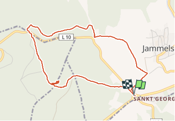
Trail Walking of 4.8 km to be discovered at Rhineland-Palatinate, Landkreis Ahrweiler, Kaltenborn. This trail is proposed by Geert H..
Description
De Hohe Acht is met zijn 747 m de hoogste top van de Eifel en is gelegen op de grens tussen de districten Ahrweiler en Mayen-Koblenz in de Duitse deelstaat Rijnland-Palts.
De Hohe Acht bevindt zich in de Hocheifel ten oosten van Adenau. De berg is een uitgedoofde vulkaan uit het Tertiair.
Op de Hohe Acht werd omstreeks 1908, 1909 de Kaiser-Wilhelm-toren gebouwd die een vergezicht biedt over de Eifel tot aan het Westerwald, de Hunsrück en de Rijn. Het bevel tot de oprichting van deze stenen uitkijktoren kwam er wegens het zilveren jubileum van keizer Wilhelm II en keizerin Augusta Victoria alsook ter herinnering van keizer Wilhelm I.
Om de Hohe Acht heen is een netwerk van wandelwegen aangelegd. Op talrijke plaatsen is hier een weids uitzicht over het Eifellandschap mogelijk.
Photos


Positioning
Comments