


Saillans chapelle st Christophe

michelineguillot
User
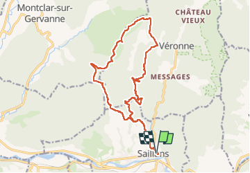

Length
19.4 km

Max alt
660 m

Uphill gradient
694 m
Km-Effort
29 km

Min alt
269 m

Downhill gradient
693 m
Boucle
Yes
Creation date :
2025-03-26 08:05:30.0
Updated on :
2025-03-26 15:46:08.705
5h18
Difficulty : Medium

FREE GPS app for hiking
 SityTrail
IGN / Geographical institutes
SityTrail Plus
The world is yours!
About
Trail Walking of 19.4 km to be discovered at Auvergne-Rhône-Alpes, Drôme, Saillans. This trail is proposed by michelineguillot.
Positioning
Country:
France
Region :
Auvergne-Rhône-Alpes
Department/Province :
Drôme
Municipality :
Saillans
Location:
Unknown
Start:(Dec)
Start:(UTM)
674228 ; 4951722 (31T) N.
Comments