


Lac de Tardevant

jacques49
User
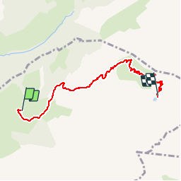

Length
6.8 km

Max alt
2129 m

Uphill gradient
721 m
Km-Effort
14.1 km

Min alt
1435 m

Downhill gradient
29 m
Boucle
No
Creation date :
2015-07-01 00:00:00.0
Updated on :
2015-07-01 00:00:00.0
2h19
Difficulty : Medium

FREE GPS app for hiking
 SityTrail
IGN / Geographical institutes
SityTrail Plus
The world is yours!
About
Trail Walking of 6.8 km to be discovered at Auvergne-Rhône-Alpes, Upper Savoy, La Clusaz. This trail is proposed by jacques49.
Positioning
Country:
France
Region :
Auvergne-Rhône-Alpes
Department/Province :
Upper Savoy
Municipality :
La Clusaz
Location:
Unknown
Start:(Dec)
Start:(UTM)
304965 ; 5088560 (32T) N.
Comments