


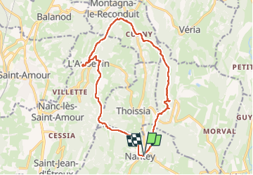
Nantey-andelot-curny

HB01
User

Length
16.6 km

Max alt
593 m

Uphill gradient
412 m
Km-Effort
22 km

Min alt
405 m

Downhill gradient
412 m
Boucle
Yes
Creation date :
2025-03-27 09:03:58.801
Updated on :
2025-03-27 14:58:03.264
4h14
Difficulty : Medium

FREE GPS app for hiking
 SityTrail
IGN / Geographical institutes
SityTrail Plus
The world is yours!
About
Trail Walking of 16.6 km to be discovered at Bourgogne-Franche-Comté, Jura, Val-d'Épy. This trail is proposed by HB01.
Photos

Positioning
Country:
France
Region :
Bourgogne-Franche-Comté
Department/Province :
Jura
Municipality :
Val-d'Épy
Location:
Unknown
Start:(Dec)
Start:(UTM)
684555 ; 5142261 (31T) N.
Comments