


Piolenc grotte

FLORENSAC
User
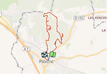

Length
9.9 km

Max alt
141 m

Uphill gradient
174 m
Km-Effort
12.2 km

Min alt
38 m

Downhill gradient
174 m
Boucle
Yes
Creation date :
2025-03-27 09:13:19.808
Updated on :
2025-03-27 15:01:07.642
5h47
Difficulty : Difficult

FREE GPS app for hiking
 SityTrail
IGN / Geographical institutes
SityTrail Plus
The world is yours!
About
Trail Walking of 9.9 km to be discovered at Provence-Alpes-Côte d'Azur, Vaucluse, Piolenc. This trail is proposed by FLORENSAC.
Description
site minier carrieres de sable
Photos


Positioning
Country:
France
Region :
Provence-Alpes-Côte d'Azur
Department/Province :
Vaucluse
Municipality :
Piolenc
Location:
Unknown
Start:(Dec)
Start:(UTM)
641007 ; 4893229 (31T) N.
Comments
Ne pas y aller sans Gps