


Amanvillers B et M

bstebe
User
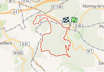

Length
8.7 km

Max alt
377 m

Uphill gradient
177 m
Km-Effort
11.1 km

Min alt
281 m

Downhill gradient
177 m
Boucle
Yes
Creation date :
2025-03-27 13:51:33.031
Updated on :
2025-03-27 18:19:22.87
2h31
Difficulty : Medium

FREE GPS app for hiking
 SityTrail
IGN / Geographical institutes
SityTrail Plus
The world is yours!
About
Trail Walking of 8.7 km to be discovered at Grand Est, Moselle, Norroy-le-Veneur. This trail is proposed by bstebe.
Positioning
Country:
France
Region :
Grand Est
Department/Province :
Moselle
Municipality :
Norroy-le-Veneur
Location:
Unknown
Start:(Dec)
Start:(UTM)
287589 ; 5450898 (32U) N.
Comments