


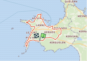
SityTrail - 4398462 - camaret-x-moyenne

guy77340
User

Length
15.3 km

Max alt
60 m

Uphill gradient
272 m
Km-Effort
18.9 km

Min alt
0 m

Downhill gradient
273 m
Boucle
Yes
Creation date :
2025-03-27 17:39:42.427
Updated on :
2025-03-28 15:05:37.563
4h18
Difficulty : Difficult

FREE GPS app for hiking
 SityTrail
IGN / Geographical institutes
SityTrail Plus
The world is yours!
About
Trail Walking of 15.3 km to be discovered at Brittany, Finistère, Camaret-sur-Mer. This trail is proposed by guy77340.
Positioning
Country:
France
Region :
Brittany
Department/Province :
Finistère
Municipality :
Camaret-sur-Mer
Location:
Unknown
Start:(Dec)
Start:(UTM)
381033 ; 5346593 (30U) N.
Comments