


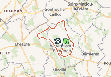
vachette sous beaumont

RoMo
User

Length
10.9 km

Max alt
145 m

Uphill gradient
103 m
Km-Effort
12.3 km

Min alt
109 m

Downhill gradient
102 m
Boucle
Yes
Creation date :
2025-03-30 07:02:33.694
Updated on :
2025-03-30 10:19:34.398
2h16
Difficulty : Easy

FREE GPS app for hiking
 SityTrail
IGN / Geographical institutes
SityTrail Plus
The world is yours!
About
Trail Walking of 10.9 km to be discovered at Normandy, Seine-Maritime, Vattetot-sous-Beaumont. This trail is proposed by RoMo.
Description
boucle campagne
Positioning
Country:
France
Region :
Normandy
Department/Province :
Seine-Maritime
Municipality :
Vattetot-sous-Beaumont
Location:
Unknown
Start:(Dec)
Start:(UTM)
315451 ; 5500081 (31U) N.
Comments