


AIN: COL DE RICHEMONT SUD

djeepee74
User
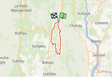

Length
14.7 km

Max alt
1266 m

Uphill gradient
457 m
Km-Effort
21 km

Min alt
931 m

Downhill gradient
461 m
Boucle
Yes
Creation date :
2025-03-30 08:07:28.303
Updated on :
2025-04-01 13:08:52.13
4h43
Difficulty : Medium

FREE GPS app for hiking
 SityTrail
IGN / Geographical institutes
SityTrail Plus
The world is yours!
About
Trail Walking of 14.7 km to be discovered at Auvergne-Rhône-Alpes, Ain, Chanay. This trail is proposed by djeepee74.
Description
BOUCLE... live du 20250330
... au départ: de la route sur 1,5 Km !
Photos


Positioning
Country:
France
Region :
Auvergne-Rhône-Alpes
Department/Province :
Ain
Municipality :
Chanay
Location:
Unknown
Start:(Dec)
Start:(UTM)
712694 ; 5098763 (31T) N.
Comments