


chirouze reco

collot
User

Length
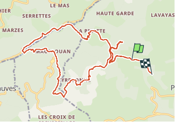
14.2 km

Max alt
729 m

Uphill gradient
571 m
Km-Effort
22 km

Min alt
340 m

Downhill gradient
642 m
Boucle
No
Creation date :
2025-03-30 08:28:00.437
Updated on :
2025-03-30 15:11:55.357
6h43
Difficulty : Difficult

FREE GPS app for hiking
 SityTrail
IGN / Geographical institutes
SityTrail Plus
The world is yours!
About
Trail Walking of 14.2 km to be discovered at Auvergne-Rhône-Alpes, Ardèche, Pranles. This trail is proposed by collot.
Description
Difficile
Positioning
Country:
France
Region :
Auvergne-Rhône-Alpes
Department/Province :
Ardèche
Municipality :
Pranles
Location:
Unknown
Start:(Dec)
Start:(UTM)
623145 ; 4959601 (31T) N.
Comments