


2025-04-01

rando30129
User
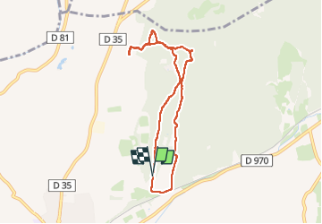

Length
7.9 km

Max alt
109 m

Uphill gradient
179 m
Km-Effort
10.3 km

Min alt
6 m

Downhill gradient
174 m
Boucle
Yes
Creation date :
2025-04-01 11:43:46.149
Updated on :
2025-04-01 14:32:18.83
2h48
Difficulty : Medium

FREE GPS app for hiking
 SityTrail
IGN / Geographical institutes
SityTrail Plus
The world is yours!
About
Trail Walking of 7.9 km to be discovered at Provence-Alpes-Côte d'Azur, Bouches-du-Rhône, Tarascon. This trail is proposed by rando30129.
Positioning
Country:
France
Region :
Provence-Alpes-Côte d'Azur
Department/Province :
Bouches-du-Rhône
Municipality :
Tarascon
Location:
Unknown
Start:(Dec)
Start:(UTM)
635457 ; 4853791 (31T) N.
Comments