


Villardonnel - Le tour du bois de la Serre

Combaut11
User
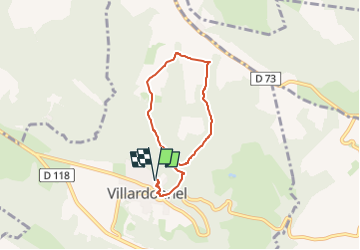

Length
6.5 km

Max alt
469 m

Uphill gradient
230 m
Km-Effort
9.5 km

Min alt
304 m

Downhill gradient
230 m
Boucle
Yes
Creation date :
2025-04-01 16:11:30.967
Updated on :
2025-04-01 16:12:26.396
2h09
Difficulty : Medium

FREE GPS app for hiking
 SityTrail
IGN / Geographical institutes
SityTrail Plus
The world is yours!
About
Trail Walking of 6.5 km to be discovered at Occitania, Aude, Villardonnel. This trail is proposed by Combaut11.
Positioning
Country:
France
Region :
Occitania
Department/Province :
Aude
Municipality :
Villardonnel
Location:
Unknown
Start:(Dec)
Start:(UTM)
444210 ; 4798467 (31T) N.
Comments