


Villespy

Mascart
User
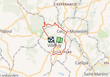

Length
10.6 km

Max alt
262 m

Uphill gradient
159 m
Km-Effort
12.7 km

Min alt
157 m

Downhill gradient
158 m
Boucle
Yes
Creation date :
2025-04-01 11:41:41.783
Updated on :
2025-04-01 18:00:25.643
3h15
Difficulty : Medium

FREE GPS app for hiking
 SityTrail
IGN / Geographical institutes
SityTrail Plus
The world is yours!
About
Trail Walking of 10.6 km to be discovered at Occitania, Aude, Villespy. This trail is proposed by Mascart.
Description
boucle autour de Villespy
Positioning
Country:
France
Region :
Occitania
Department/Province :
Aude
Municipality :
Villespy
Location:
Unknown
Start:(Dec)
Start:(UTM)
426877 ; 4796584 (31T) N.
Comments