


2

francois58
User
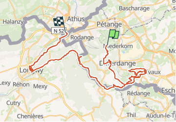

Length
43 km

Max alt
423 m

Uphill gradient
546 m
Km-Effort
51 km

Min alt
253 m

Downhill gradient
687 m
Boucle
No
Creation date :
2025-04-02 10:48:14.0
Updated on :
2025-04-02 14:46:04.18

FREE GPS app for hiking
 SityTrail
IGN / Geographical institutes
SityTrail Plus
The world is yours!
About
Trail of 43 km to be discovered at Unknown, Canton Esch-sur-Alzette, Differdange. This trail is proposed by francois58.
Positioning
Country:
Luxembourg
Region :
Unknown
Department/Province :
Canton Esch-sur-Alzette
Municipality :
Differdange
Location:
Unknown
Start:(Dec)
Start:(UTM)
707998 ; 5491136 (31U) N.
Comments