


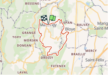
ALBANAIS: MASSINGY TOUR SUD

djeepee74
User

Length
13.1 km

Max alt
626 m

Uphill gradient
393 m
Km-Effort
18.3 km

Min alt
374 m

Downhill gradient
393 m
Boucle
Yes
Creation date :
2016-03-09 00:00:00.0
Updated on :
2020-02-06 09:12:00.981
4h00
Difficulty : Medium

FREE GPS app for hiking
 SityTrail
IGN / Geographical institutes
SityTrail Plus
The world is yours!
About
Trail Walking of 13.1 km to be discovered at Auvergne-Rhône-Alpes, Upper Savoy, Massingy. This trail is proposed by djeepee74.
Description
BOUCLE
Randonnée organisée par les Amis du Patrimoine de Massingy le 21 juin 2016 (tracé de André DEPREZ)
Positioning
Country:
France
Region :
Auvergne-Rhône-Alpes
Department/Province :
Upper Savoy
Municipality :
Massingy
Location:
Unknown
Start:(Dec)
Start:(UTM)
726768 ; 5079196 (31T) N.
Comments