


ste_marguerite_stpal_collat_55km-19592581-1743610959-724

topolino
User
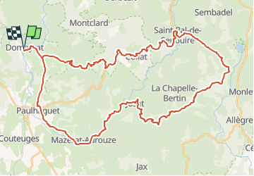

Length
55 km

Max alt
1094 m

Uphill gradient
1073 m
Km-Effort
69 km

Min alt
490 m

Downhill gradient
1069 m
Boucle
Yes
Creation date :
2025-04-02 16:26:06.928
Updated on :
2025-04-02 16:28:02.924
--
Difficulty : Very difficult

FREE GPS app for hiking
 SityTrail
IGN / Geographical institutes
SityTrail Plus
The world is yours!
About
Trail Bicycle tourism of 55 km to be discovered at Auvergne-Rhône-Alpes, Haute-Loire, Domeyrat. This trail is proposed by topolino.
Positioning
Country:
France
Region :
Auvergne-Rhône-Alpes
Department/Province :
Haute-Loire
Municipality :
Domeyrat
Location:
Unknown
Start:(Dec)
Start:(UTM)
539424 ; 5010819 (31T) N.
Comments