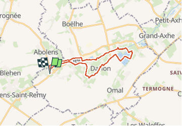
Trail Walking Geer - Geer 010425 - Photo

Geer 010425

© OpenStreetMap contributors
Length
Length
11.9 km
Max alt
Max alt
134 m
Uphill gradient
Uphill gradient
76 m
Km-Effort
Km-Effort  
12.9 km
Min alt
Min alt
119 m
Downhill gradient
Downhill gradient
76 m
Boucle
Boucle
Yes
Creation date :
2025-04-01 09:07:44.875
Updated on :
2025-04-04 07:57:20.337

(0 Reviews)

Walking
Walking
3h07
Difficulty : Easy

Scan this QR Code to open this trail in the SityTrail application

FREE GPS app for hiking

Logo SityTrail SityTrail

IGN / Geographical institutes

Download SityTrail from the App Store Download SityTrail from Google Play

Logo SityTrail SityTrail Plus

The world is yours!

Download SityTrail from the App Store Download SityTrail from Google Play Download SityTrail on Huawei AppGallery

About

Trail Walking of 11.9 km to be discovered at Wallonia, Liège, Geer. This trail is proposed by guyernage25.

Description

belle rando suivant la vallée du Geer
Attention après la réserve naturelle de Hollogne, ne pas prendre à gauche car la passerelle enjambant le Geer est démolie donc passer par Hollogne

Elevation profile

Photos

27 photos in total. Please click on a photo to see them all in the gallery.

Positioning

Country:
Belgium
Region :
Wallonia
Department/Province :
Liège
Municipality :
Geer
Location:
Unknown
Start:(UTM)
652150 ; 5614495 (31U) N.


Close
My subscriptions