


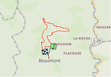
Beaumont Col des Cayras

pb07
User

Length
6.7 km

Max alt
779 m

Uphill gradient
239 m
Km-Effort
9.8 km

Min alt
578 m

Downhill gradient
234 m
Boucle
No
Creation date :
2025-04-04 12:54:46.306
Updated on :
2025-04-04 15:17:58.707
2h22
Difficulty : Medium

FREE GPS app for hiking
 SityTrail
IGN / Geographical institutes
SityTrail Plus
The world is yours!
About
Trail Walking of 6.7 km to be discovered at Auvergne-Rhône-Alpes, Ardèche, Beaumont. This trail is proposed by pb07.
Positioning
Country:
France
Region :
Auvergne-Rhône-Alpes
Department/Province :
Ardèche
Municipality :
Beaumont
Location:
Unknown
Start:(Dec)
Start:(UTM)
592765 ; 4932500 (31T) N.
Comments