


etang d'arfin Laetitia

michelrenaud
User
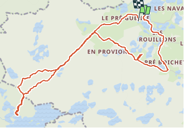

Length
6.6 km

Max alt
609 m

Uphill gradient
94 m
Km-Effort
7.8 km

Min alt
553 m

Downhill gradient
89 m
Boucle
Yes
Creation date :
2025-04-04 13:31:58.735
Updated on :
2025-04-04 16:18:15.613
2h45
Difficulty : Very easy

FREE GPS app for hiking
 SityTrail
IGN / Geographical institutes
SityTrail Plus
The world is yours!
About
Trail Walking of 6.6 km to be discovered at Bourgogne-Franche-Comté, Haute-Saône, Servance-Miellin. This trail is proposed by michelrenaud.
Positioning
Country:
France
Region :
Bourgogne-Franche-Comté
Department/Province :
Haute-Saône
Municipality :
Servance-Miellin
Location:
Servance
Start:(Dec)
Start:(UTM)
324270 ; 5300803 (32T) N.
Comments