


tt

chuck
User
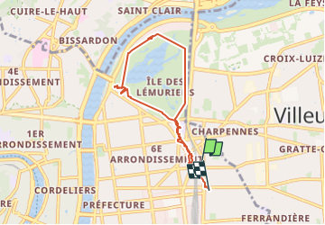

Length
6.7 km

Max alt
184 m

Uphill gradient
66 m
Km-Effort
7.5 km

Min alt
166 m

Downhill gradient
65 m
Boucle
No
Creation date :
2025-04-05 06:51:47.943
Updated on :
2025-04-05 07:32:49.052
40m
Difficulty : Very easy

FREE GPS app for hiking
 SityTrail
IGN / Geographical institutes
SityTrail Plus
The world is yours!
About
Trail Trail of 6.7 km to be discovered at Auvergne-Rhône-Alpes, Métropole de Lyon, Lyon. This trail is proposed by chuck.
Positioning
Country:
France
Region :
Auvergne-Rhône-Alpes
Department/Province :
Métropole de Lyon
Municipality :
Lyon
Location:
Lyon 6e Arrondissement
Start:(Dec)
Start:(UTM)
644726 ; 5069761 (31T) N.
Comments