


Sturzebronn BS 2025

bstebe
User
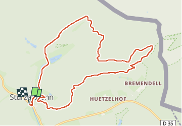

Length
11.5 km

Max alt
382 m

Uphill gradient
289 m
Km-Effort
15.3 km

Min alt
245 m

Downhill gradient
289 m
Boucle
Yes
Creation date :
2025-04-05 06:49:51.863
Updated on :
2025-04-05 10:08:49.06
3h18
Difficulty : Difficult

FREE GPS app for hiking
 SityTrail
IGN / Geographical institutes
SityTrail Plus
The world is yours!
About
Trail Walking of 11.5 km to be discovered at Grand Est, Moselle, Sturzelbronn. This trail is proposed by bstebe.
Positioning
Country:
France
Region :
Grand Est
Department/Province :
Moselle
Municipality :
Sturzelbronn
Location:
Unknown
Start:(Dec)
Start:(UTM)
396743 ; 5434544 (32U) N.
Comments