


autour de St Saturnin depuis Rabieux

Lionel Verdoucq 2
User
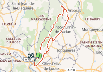

Length
17 km

Max alt
303 m

Uphill gradient
353 m
Km-Effort
22 km

Min alt
79 m

Downhill gradient
352 m
Boucle
Yes
Creation date :
2025-04-05 07:19:11.225
Updated on :
2025-04-05 10:46:41.639
3h26
Difficulty : Medium

FREE GPS app for hiking
 SityTrail
IGN / Geographical institutes
SityTrail Plus
The world is yours!
About
Trail Walking of 17 km to be discovered at Occitania, Hérault, Ceyras. This trail is proposed by Lionel Verdoucq 2.
Description
Boucle de 17 kms, avec un D de 300m. Le retour se fait principalement par des petites routes de campagne, peu passantes, mais sans beaucoup d'ombre. À déconseiller en plein été.
Positioning
Country:
France
Region :
Occitania
Department/Province :
Hérault
Municipality :
Ceyras
Location:
Unknown
Start:(Dec)
Start:(UTM)
535321 ; 4834897 (31T) N.
Comments