


marche de la Cerise à Niedereggenen

patrickbeyrath
User
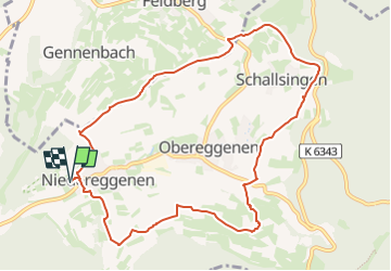

Length
10.2 km

Max alt
485 m

Uphill gradient
279 m
Km-Effort
13.9 km

Min alt
297 m

Downhill gradient
279 m
Boucle
Yes
Creation date :
2025-04-06 06:44:29.817
Updated on :
2025-04-06 07:47:53.054
3h09
Difficulty : Medium

FREE GPS app for hiking
 SityTrail
IGN / Geographical institutes
SityTrail Plus
The world is yours!
About
Trail Walking of 10.2 km to be discovered at Baden-Württemberg, Landkreis Lörrach, Schliengen. This trail is proposed by patrickbeyrath.
Positioning
Country:
Germany
Region :
Baden-Württemberg
Department/Province :
Landkreis Lörrach
Municipality :
Schliengen
Location:
Unknown
Start:(Dec)
Start:(UTM)
396970 ; 5289882 (32T) N.
Comments