


fleuries 10km v&d

MSOH77
User
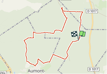

Length
9.9 km

Max alt
152 m

Uphill gradient
137 m
Km-Effort
11.8 km

Min alt
99 m

Downhill gradient
141 m
Boucle
Yes
Creation date :
2025-04-06 07:30:53.823
Updated on :
2025-04-06 10:13:26.35
2h42
Difficulty : Medium

FREE GPS app for hiking
 SityTrail
IGN / Geographical institutes
SityTrail Plus
The world is yours!
About
Trail Walking of 9.9 km to be discovered at Hauts-de-France, Oise, Senlis. This trail is proposed by MSOH77.
Positioning
Country:
France
Region :
Hauts-de-France
Department/Province :
Oise
Municipality :
Senlis
Location:
Unknown
Start:(Dec)
Start:(UTM)
469315 ; 5454421 (31U) N.
Comments