


Cresta le poirier reco

collot
User
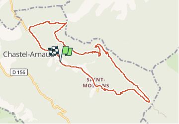

Length
11.4 km

Max alt
883 m

Uphill gradient
563 m
Km-Effort
18.9 km

Min alt
394 m

Downhill gradient
559 m
Boucle
Yes
Creation date :
2025-04-06 07:41:52.66
Updated on :
2025-04-06 14:08:34.099
6h26
Difficulty : Medium

FREE GPS app for hiking
 SityTrail
IGN / Geographical institutes
SityTrail Plus
The world is yours!
About
Trail Walking of 11.4 km to be discovered at Auvergne-Rhône-Alpes, Drôme, Chastel-Arnaud. This trail is proposed by collot.
Description
Sympa.
Positioning
Country:
France
Region :
Auvergne-Rhône-Alpes
Department/Province :
Drôme
Municipality :
Chastel-Arnaud
Location:
Unknown
Start:(Dec)
Start:(UTM)
675357 ; 4947881 (31T) N.
Comments