


Tervuren golf HR 2025.04.06 réel

José Leveau
User
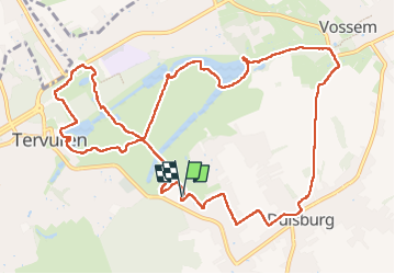

Length
12.5 km

Max alt
102 m

Uphill gradient
189 m
Km-Effort
15 km

Min alt
53 m

Downhill gradient
190 m
Boucle
Yes
Creation date :
2025-04-06 09:22:56.878
Updated on :
2025-04-11 19:33:52.271
3h08
Difficulty : Medium

FREE GPS app for hiking
 SityTrail
IGN / Geographical institutes
SityTrail Plus
The world is yours!
About
Trail Walking of 12.5 km to be discovered at Flanders, Flemish Brabant, Tervuren. This trail is proposed by José Leveau .
Positioning
Country:
Belgium
Region :
Flanders
Department/Province :
Flemish Brabant
Municipality :
Tervuren
Location:
Duisburg
Start:(Dec)
Start:(UTM)
608110 ; 5630769 (31U) N.
Comments