


gr34 Dinard saint Malo

taguette
User
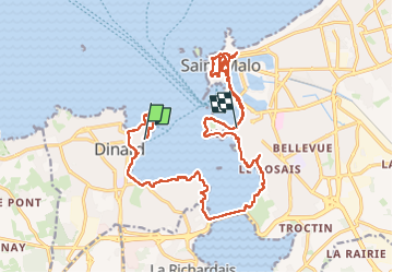

Length
21 km

Max alt
38 m

Uphill gradient
326 m
Km-Effort
25 km

Min alt
0 m

Downhill gradient
330 m
Boucle
No
Creation date :
2025-04-05 07:16:47.614
Updated on :
2025-04-06 14:49:39.52
7h19
Difficulty : Very difficult

FREE GPS app for hiking
 SityTrail
IGN / Geographical institutes
SityTrail Plus
The world is yours!
About
Trail Walking of 21 km to be discovered at Brittany, Ille-et-Vilaine, Dinard. This trail is proposed by taguette.
Positioning
Country:
France
Region :
Brittany
Department/Province :
Ille-et-Vilaine
Municipality :
Dinard
Location:
Unknown
Start:(Dec)
Start:(UTM)
569996 ; 5387197 (30U) N.
Comments