


parcours boult sur suippes 8 kms

quatre sans cinq
User
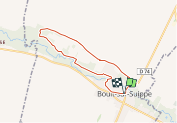

Length
6.7 km

Max alt
76 m

Uphill gradient
39 m
Km-Effort
7.2 km

Min alt
66 m

Downhill gradient
38 m
Boucle
Yes
Creation date :
2025-04-07 12:56:33.571
Updated on :
2025-04-07 12:57:21.628
1h38
Difficulty : Medium

FREE GPS app for hiking
 SityTrail
IGN / Geographical institutes
SityTrail Plus
The world is yours!
About
Trail Walking of 6.7 km to be discovered at Grand Est, Marne, Boult-sur-Suippe. This trail is proposed by quatre sans cinq.
Positioning
Country:
France
Region :
Grand Est
Department/Province :
Marne
Municipality :
Boult-sur-Suippe
Location:
Unknown
Start:(Dec)
Start:(UTM)
583321 ; 5469315 (31U) N.
Comments