


2015-07-05- Villemoisson sur Orge

Lucquiaud
User
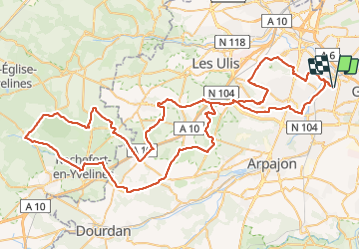

Length
105 km

Max alt
181 m

Uphill gradient
1073 m
Km-Effort
120 km

Min alt
38 m

Downhill gradient
1072 m
Boucle
Yes
Creation date :
2018-09-15 15:06:07.044
Updated on :
2018-09-15 15:06:07.348
5h07
Difficulty : Medium

FREE GPS app for hiking
 SityTrail
IGN / Geographical institutes
SityTrail Plus
The world is yours!
About
Trail Cycle of 105 km to be discovered at Ile-de-France, Essonne, Villemoisson-sur-Orge. This trail is proposed by Lucquiaud.
Positioning
Country:
France
Region :
Ile-de-France
Department/Province :
Essonne
Municipality :
Villemoisson-sur-Orge
Location:
Unknown
Start:(Dec)
Start:(UTM)
450845 ; 5389709 (31U) N.
Comments