


Gr34 st Malo Cancale camp

taguette
User
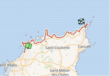

Length
24 km

Max alt
39 m

Uphill gradient
376 m
Km-Effort
29 km

Min alt
-1 m

Downhill gradient
364 m
Boucle
No
Creation date :
2025-04-07 07:02:50.399
Updated on :
2025-04-07 15:29:08.339
8h25
Difficulty : Very difficult

FREE GPS app for hiking
 SityTrail
IGN / Geographical institutes
SityTrail Plus
The world is yours!
About
Trail Walking of 24 km to be discovered at Brittany, Ille-et-Vilaine, Saint-Malo. This trail is proposed by taguette.
Positioning
Country:
France
Region :
Brittany
Department/Province :
Ille-et-Vilaine
Municipality :
Saint-Malo
Location:
Unknown
Start:(Dec)
Start:(UTM)
574700 ; 5391042 (30U) N.
Comments