


cap Fréhel 04 25

taguette
User

Length
14.6 km

Max alt
76 m

Uphill gradient
266 m
Km-Effort
18.2 km

Min alt
5 m

Downhill gradient
261 m
Boucle
No
Creation date :
2025-04-08 07:20:35.521
Updated on :
2025-04-08 12:32:10.022
5h10
Difficulty : Difficult

FREE GPS app for hiking
 SityTrail
IGN / Geographical institutes
SityTrail Plus
The world is yours!
About
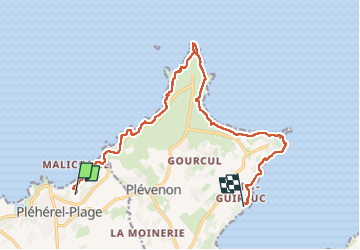
Trail Walking of 14.6 km to be discovered at Brittany, Côtes-d'Armor, Fréhel. This trail is proposed by taguette.
Positioning
Country:
France
Region :
Brittany
Department/Province :
Côtes-d'Armor
Municipality :
Fréhel
Location:
Unknown
Start:(Dec)
Start:(UTM)
547255 ; 5389156 (30U) N.
Comments