


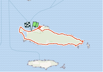
Tour de l'Ile Sainte-Marguerite

Clo0413
User

Length
8.7 km

Max alt
42 m

Uphill gradient
151 m
Km-Effort
10.8 km

Min alt
-1 m

Downhill gradient
148 m
Boucle
Yes
Creation date :
2025-04-08 08:29:48.838
Updated on :
2025-04-11 16:23:00.051
2h27
Difficulty : Easy

FREE GPS app for hiking
 SityTrail
IGN / Geographical institutes
SityTrail Plus
The world is yours!
About
Trail Walking of 8.7 km to be discovered at Provence-Alpes-Côte d'Azur, Maritime Alps, Cannes. This trail is proposed by Clo0413.
Positioning
Country:
France
Region :
Provence-Alpes-Côte d'Azur
Department/Province :
Maritime Alps
Municipality :
Cannes
Location:
Unknown
Start:(Dec)
Start:(UTM)
341520 ; 4820642 (32T) N.
Comments