


2025-04-08 mikeou

guyverot
User
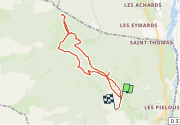

Length
8.6 km

Max alt
1807 m

Uphill gradient
419 m
Km-Effort
14.4 km

Min alt
1373 m

Downhill gradient
457 m
Boucle
No
Creation date :
2025-04-08 07:46:47.397
Updated on :
2025-04-08 13:15:52.799
2h47
Difficulty : Easy

FREE GPS app for hiking
 SityTrail
IGN / Geographical institutes
SityTrail Plus
The world is yours!
About
Trail Walking of 8.6 km to be discovered at Provence-Alpes-Côte d'Azur, Hautes-Alpes, Réotier. This trail is proposed by guyverot.
Positioning
Country:
France
Region :
Provence-Alpes-Côte d'Azur
Department/Province :
Hautes-Alpes
Municipality :
Réotier
Location:
Unknown
Start:(Dec)
Start:(UTM)
308834 ; 4949668 (32T) N.
Comments