


rs lamarque

LouisROGER
User GUIDE
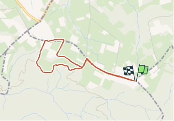

Length
5.7 km

Max alt
528 m

Uphill gradient
71 m
Km-Effort
6.6 km

Min alt
481 m

Downhill gradient
71 m
Boucle
Yes
Creation date :
2025-04-08 12:11:38.149
Updated on :
2025-04-08 14:13:52.483
2h01
Difficulty : Medium

FREE GPS app for hiking
 SityTrail
IGN / Geographical institutes
SityTrail Plus
The world is yours!
About
Trail Walking of 5.7 km to be discovered at Occitania, Hautespyrenees, Barlest. This trail is proposed by LouisROGER.
Positioning
Country:
France
Region :
Occitania
Department/Province :
Hautespyrenees
Municipality :
Barlest
Location:
Unknown
Start:(Dec)
Start:(UTM)
734577 ; 4780992 (30T) N.
Comments