


2024 04 09 balade CARTES

hal2012
User
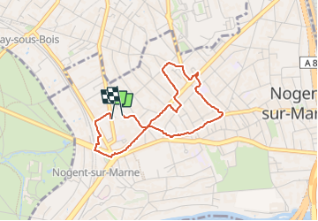

Length
3.2 km

Max alt
92 m

Uphill gradient
31 m
Km-Effort
3.7 km

Min alt
63 m

Downhill gradient
29 m
Boucle
Yes
Creation date :
2025-04-09 05:57:55.491
Updated on :
2025-04-09 06:38:53.925
40m
Difficulty : Easy

FREE GPS app for hiking
 SityTrail
IGN / Geographical institutes
SityTrail Plus
The world is yours!
About
Trail Walking of 3.2 km to be discovered at Ile-de-France, Val-de-Marne, Nogent-sur-Marne. This trail is proposed by hal2012.
Positioning
Country:
France
Region :
Ile-de-France
Department/Province :
Val-de-Marne
Municipality :
Nogent-sur-Marne
Location:
Unknown
Start:(Dec)
Start:(UTM)
461361 ; 5409556 (31U) N.
Comments