


09/04/2025 Rando ski Pic Nègre d'Envalira

chrisbal
User
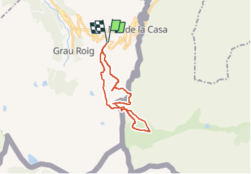

Length
12.5 km

Max alt
2792 m

Uphill gradient
1101 m
Km-Effort
27 km

Min alt
2326 m

Downhill gradient
1096 m
Boucle
Yes
Creation date :
2025-04-09 06:18:13.416
Updated on :
2025-04-10 15:16:07.393
3h26
Difficulty : Difficult

FREE GPS app for hiking
 SityTrail
IGN / Geographical institutes
SityTrail Plus
The world is yours!
About
Trail Touring skiing of 12.5 km to be discovered at Andorra. This trail is proposed by chrisbal.
Positioning
Country:
Andorra
Region :
Unknown
Department/Province :
Unknown
Municipality :
Unknown
Location:
Unknown
Start:(Dec)
Start:(UTM)
394816 ; 4710515 (31T) N.
Comments