


brioude-champagnac

topolino
User
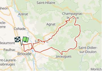

Length
41 km

Max alt
938 m

Uphill gradient
859 m
Km-Effort
53 km

Min alt
414 m

Downhill gradient
858 m
Boucle
Yes
Creation date :
2025-04-09 13:47:36.643
Updated on :
2025-04-09 13:47:36.643
3h39
Difficulty : Very difficult

FREE GPS app for hiking
 SityTrail
IGN / Geographical institutes
SityTrail Plus
The world is yours!
About
Trail Mountain bike of 41 km to be discovered at Auvergne-Rhône-Alpes, Haute-Loire, Brioude. This trail is proposed by topolino.
Positioning
Country:
France
Region :
Auvergne-Rhône-Alpes
Department/Province :
Haute-Loire
Municipality :
Brioude
Location:
Unknown
Start:(Dec)
Start:(UTM)
529688 ; 5017195 (31T) N.
Comments