


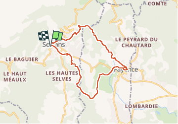
Seillans- Fayence

Gilles Auffret
User

Length
16.3 km

Max alt
565 m

Uphill gradient
486 m
Km-Effort
23 km

Min alt
242 m

Downhill gradient
488 m
Boucle
Yes
Creation date :
2025-04-09 07:19:22.0
Updated on :
2025-04-09 14:08:57.631
4h17
Difficulty : Very difficult

FREE GPS app for hiking
 SityTrail
IGN / Geographical institutes
SityTrail Plus
The world is yours!
About
Trail Walking of 16.3 km to be discovered at Provence-Alpes-Côte d'Azur, Var, Seillans. This trail is proposed by Gilles Auffret.
Positioning
Country:
France
Region :
Provence-Alpes-Côte d'Azur
Department/Province :
Var
Municipality :
Seillans
Location:
Unknown
Start:(Dec)
Start:(UTM)
309846 ; 4834065 (32T) N.
Comments